File:Liberty flood plain management study, Casey County, Kentucky - flood hazard area, Liberty LOC 92682550.jpg

Size of this preview: 733 × 600 pixels. Other resolutions: 293 × 240 pixels | 587 × 480 pixels | 939 × 768 pixels | 1,252 × 1,024 pixels | 2,503 × 2,048 pixels | 8,475 × 6,935 pixels.
Original file (8,475 × 6,935 pixels, file size: 6.88 MB, MIME type: image/jpeg)
Captions
Captions
Add a one-line explanation of what this file represents
Summary
edit| Description |
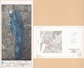
English: Photomap showing 1 % and 0.2 % chance flood limits. In left lower margin: October 1990 1006554. Sheet numbered: Sheet 1 of 1. "1988 KDOT photography." Oriented with north toward upper left. Accompanied by: Photomap sheet location and vicinity map, Liberty, floodplain management study, Casey County, Kentucky. 1 sheet : col. ; 28 cm. Includes note. Available also through the Library of Congress Web site as a raster image. |
||
| Title | Liberty flood plain management study, Casey County, Kentucky : flood hazard area, Liberty | ||
| Shelf ID | G3954.L42C32 1990 .U5 | ||
| Date | |||
| Source | https://www.loc.gov/item/92682550/ | ||
| Author | United States. Soil Conservation Service | ||
| Permission (Reusing this file) |
|
||
| Other versions |
|
||
| Location | United States · Casey County · Kentucky · Liberty. · Liberty | ||
| Part of | American Memory · Cities And Towns · Catalog · Geography And Map Division · Additional Conservation And Environment Cartographic Items | ||
| Subject | Floodplains · United States · Liberty (Casey County) · Kentucky · Liberty (Casey County, Ky.) · Maps · Remote-Sensing Maps · Liberty |

Licensing
edit
| This work is from the Library of Congress. According to the library, there are no known copyright restrictions on the use of this work. |  |
File history
Click on a date/time to view the file as it appeared at that time.
| Date/Time | Thumbnail | Dimensions | User | Comment | |
|---|---|---|---|---|---|
| current | 20:22, 19 January 2019 | | 8,475 × 6,935 (6.88 MB) | Fæ (talk | contribs) | LOC Maps https://www.loc.gov/item/92682550/ #17832 |
You cannot overwrite this file.
File usage on Commons
The following 2 pages use this file: