File:Lithologic groups, Arkansas-White-Red River basin - Colfax, Curry, Guadalupe, Harding, Mora, Quay, San Miguel, and Union counties, New Mexico. LOC 2003621375.jpg

Size of this preview: 800 × 527 pixels. Other resolutions: 320 × 211 pixels | 640 × 421 pixels | 1,024 × 674 pixels | 1,280 × 843 pixels | 2,560 × 1,685 pixels | 4,877 × 3,211 pixels.
Original file (4,877 × 3,211 pixels, file size: 1.89 MB, MIME type: image/jpeg)
Captions
Captions
Add a one-line explanation of what this file represents
Summary edit
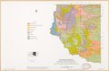
| Description |
English: "July 1978." "Base map prepared by SCS, Portland Carto Unit from USGS 1:1,000,000 national atlas. Thematic detail prepared by state staff from Geologic Map of New Mexico by Carle H. Dane and George O. Bachman, 1965 U.S. Dept. of Interior Geological Survey." Includes location map. "M7-EN-22828-12." Available also through the Library of Congress Web site as a raster image. |
||
| Title | Lithologic groups, Arkansas-White-Red River basin : Colfax, Curry, Guadalupe, Harding, Mora, Quay, San Miguel, and Union counties, New Mexico. | ||
| Shelf ID | G4052.A7C57 1978 .U5 | ||
| Date | |||
| Source | https://www.loc.gov/item/2003621375/ | ||
| Author | United States. Soil Conservation Service | ||
| Permission (Reusing this file) |
|
||
| Other versions |
|
||
| Location | Arkansas River Region · Red River Region · Red River Watershed · White River Watershed · United States · White River Region · Red River Watershed. · Arkansas · White River Watershed. · Arkansas River Watershed. · Arkansas River Watershed | ||
| Part of | American Memory · Catalog · Geography And Map Division · Additional Conservation And Environment Cartographic Items | ||
| Subject | Arkansas River Region · Petrology · Red River Region · Maps · Red River Watershed · White River Watershed · United States · White River Region · Arkansas · Arkansas River Watershed |

Licensing edit
| This work is from the Library of Congress. According to the library, there are no known copyright restrictions on the use of this work. |  |
File history
Click on a date/time to view the file as it appeared at that time.
| Date/Time | Thumbnail | Dimensions | User | Comment | |
|---|---|---|---|---|---|
| current | 18:48, 26 January 2020 | | 4,877 × 3,211 (1.89 MB) | Fæ (talk | contribs) | LOC Maps https://www.loc.gov/item/2003621375/ #11075 |
You cannot overwrite this file.
File usage on Commons
The following page uses this file: