File:Luftaufnahme Kiel (Kiel 27.727).jpg

Original file (1,024 × 675 pixels, file size: 210 KB, MIME type: image/jpeg)
Captions
Captions
Summary
edit| Description |
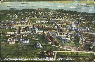
Deutsch: Aufgenommen vom Flugzeug bei 600 m Höhe. Blick vom Wasserturm Ravensberg über die Holtenauer Straße und die Feldstraße nach Düsternbrook. Die Straßen v.l.n.r.: Hardenbergstraße, Esmarchstraße, Steinstraße, Wrangelstraße, Bremerstraße und Beselerallee. |
|||||||||||||||||||||||
| Date | circa 1912 | |||||||||||||||||||||||
| Source |
|
|||||||||||||||||||||||
| Author | Spörke, Otto (1880-1942) | |||||||||||||||||||||||
| Permission (Reusing this file) |
Gemeinfrei (Public Domain Mark 1.0) | |||||||||||||||||||||||
| Identity | 27.727 | |||||||||||||||||||||||
| Title | Luftaufnahme Kiel | |||||||||||||||||||||||

.jpg&action=edit§ion=1)
Licensing
edit.jpg&action=edit§ion=2)
|
This work is in the public domain in its country of origin and other countries and areas where the copyright term is the author's life plus 70 years or fewer.
| |
| This file has been identified as being free of known restrictions under copyright law, including all related and neighboring rights. | |
File history
Click on a date/time to view the file as it appeared at that time.
| Date/Time | Thumbnail | Dimensions | User | Comment | |
|---|---|---|---|---|---|
| current | 10:37, 23 May 2018 | | 1,024 × 675 (210 KB) | Fæ (talk | contribs) | Stadtarchive Kiel 27.727 #5258 |
You cannot overwrite this file.
File usage on Commons
There are no pages that use this file.
.jpg&oldid=415537622)