File:MEDIEVAL VESSEL (FindID 849055).jpg

Original file (637 × 744 pixels, file size: 482 KB, MIME type: image/jpeg)
Captions
Captions
Summary
edit.jpg&action=edit§ion=1)
| MEDIEVAL VESSEL | |||
|---|---|---|---|
| Photographer |
Birmingham Museums Trust, Henry Nead, 2017-06-29 14:52:53 |
||
| Title |
MEDIEVAL VESSEL |
||
| Description |
English: Eardisland History and Heritage Group
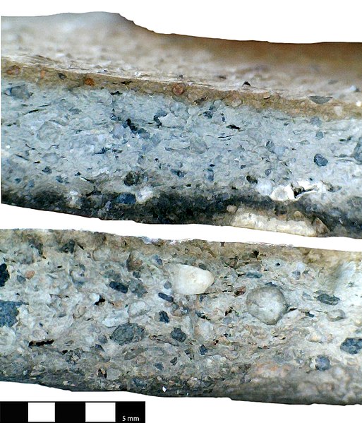
Eardisland Excavation 2000-2010 Site Summary: Finds were made during the excavation of a mound in the grounds adjacent to the dwelling: Burton Court Eardisland. The trench in which the majority of artefacts were found measured 5 metres by 3 metres. The stratified assemblage of pottery is of regional importance being especially well preserved and evidence for a domestic non-castle medieval site dating from the twelfth to early thirteenth centuries (1100-1250) Site number: BC 00 Context number: 102 Two conjoining sherds from a single body sherds of local Herefordshire silty micaceous Ware Fabric Type HER (Hereford) A3. Medieval cooking pot with silt-stone tempering with sooting on exterior surface. The fragment measures.: 1: 66.9mm in length, 44.9mm width, 4.9mm thick and weighs 20 grams. 2: 40.9mm in length, 15.1mm width, 4.9mm thick and weighs 4 grams. ___________________________________________________________ Sherd specific details: Fabric Type: Wheel thrown: Herefordshire silty micaceous Ware Fabric Type HER (Hereford) A3. Fabric Condition: A hard fabric with inclusions. Firing Condition: Dark buff to light brown throughout. Surface texture: Exterior is black with sooting; interior dark buff to light brown with visible inclusions; core grey Condition of sherd. good / unabarded Inclusions: Sparse angular and rounded quartz grains (0.4mm) rounded grey (?) micaceous gravel (1-2mm with some up to 4.0mm) sparse angular grey to black coloured grit with infrequent red grit, Sparse soft white limestone. Glaze: None Class: Herefordshire silty micaceous Ware Fabric Type HER (Hereford) A3 Comments: Dr. Alan Vince - identified this as Herefordshire silty micaceous Ware Fabric A3 and states that this was probably locally produced but no production sites / kilns are known. The fabric has the following distinguishing feature: are the presence of rounded fragmnets of fine-grained grey sandstones and fragments of rounded quarts (up to 1mm across). The groundmass is silty and micaceous. These features all indicate a source in Herefordshire; the silt micaceous clay is probably the Devonian Marl or Boulder Clay derived from this marl whilst the sandstones and quartz grains are probably derived from the outcrops of Silurian Rock and Old Red Sandstone. At Hereford, this ware first appears in assemblages dating to the later 12th or earlier 13th centuries and is one of the earliest wares found there to be locally produced. No production sites are known, but a source in or close to Hereford is likely. Other vessels known from this fabric include handmade cooking pots which are straight sided and incompletely oxidised but with brown oxidised surfaces, Tripod pitchers with gglobular bodies are also known - these have cylindrical or everted rims. Note: Vince notes that this fabric has sandstone and quartz inclusions which are more common in cooking pots. Only a few grains exceed 1mm. The colour varies with the type of vessel. |
||
| Depicted place | (County of findspot) County of Herefordshire | ||
| Date | MEDIEVAL | ||
| Accession number |
FindID: 849055 Old ref: HESH-567F72 Filename: HESH567F72Micro.jpg |
||
| Credit line |
|
||
| Source |
https://finds.org.uk/database/ajax/download/id/620579 Catalog: https://finds.org.uk/database/images/image/id/620579/recordtype/artefacts archive copy at the Wayback Machine Artefact: https://finds.org.uk/database/artefacts/record/id/849055 |
||
| Permission (Reusing this file) |
Attribution License version 2.0 (verified 3 December 2020) | ||
| Object location | | View this and other nearby images on: OpenStreetMap |
|---|
.jpg¶ms=052.220300_N_-002.851680_E_globe:Earth_class:object_type:object__&language=en)
Licensing
edit.jpg&action=edit§ion=2)
- You are free:
- to share – to copy, distribute and transmit the work
- to remix – to adapt the work
- Under the following conditions:
- attribution – You must give appropriate credit, provide a link to the license, and indicate if changes were made. You may do so in any reasonable manner, but not in any way that suggests the licensor endorses you or your use.
File history
Click on a date/time to view the file as it appeared at that time.
| Date/Time | Thumbnail | Dimensions | User | Comment | |
|---|---|---|---|---|---|
| current | 04:32, 15 December 2018 | | 637 × 744 (482 KB) | Fæ (talk | contribs) | Portable Antiquities Scheme, HESH, FindID: 849055, medieval, page 1420, batch count 3778 |
You cannot overwrite this file.
File usage on Commons
The following page uses this file:
.jpg)
.jpg&oldid=648897452)