File:Map A. LOC 77693822.tif

Size of this JPG preview of this TIF file: 800 × 561 pixels. Other resolutions: 320 × 224 pixels | 640 × 448 pixels | 1,024 × 717 pixels | 1,280 × 897 pixels | 2,560 × 1,794 pixels | 7,971 × 5,585 pixels.
Original file (7,971 × 5,585 pixels, file size: 127.37 MB, MIME type: image/tiff)
Captions
Captions
Add a one-line explanation of what this file represents
Summary edit
| Description |
English: Scale 1:211,200. "Proportion of vertical scale = 4 feet." Relief shown by form lines. Shows Dorchester, Somerset, and Worcester Counties on the Eastern Shore of Maryland. Shows soil types. Issued with 5 other maps. Accompanied by: Report of the engineer & geologist, in relation to the new map, to the executive of Maryland. 1836. 89 p. diagr. chart. Available also through the Library of Congress Web site as a raster image. AACR2: 100; 651/1; 650/2 |
||
| Title | Map A. | ||
| Shelf ID | G3842.E2 1835 .A4 | ||
| Date | |||
| Source | https://www.loc.gov/item/77693822/ | ||
| Author | [Alexander, J. H. (John Henry); Schwanecker, A. | ||
| Permission (Reusing this file) |
|
||
| Other versions |
|
||
| Location | United States · Eastern Shore · Maryland · Eastern Shore. · Virginia | ||
| Part of | American Memory · General Maps · Catalog · Geography And Map Division · Additional Conservation And Environment Cartographic Items | ||
| Subject | Soils · United States · Maps · Eastern Shore (Md. And Va.) · Maryland · Eastern Shore |


Licensing edit
|
This is a faithful photographic reproduction of a two-dimensional, public domain work of art. The work of art itself is in the public domain for the following reason:
The official position taken by the Wikimedia Foundation is that "faithful reproductions of two-dimensional public domain works of art are public domain".
This photographic reproduction is therefore also considered to be in the public domain in the United States. In other jurisdictions, re-use of this content may be restricted; see Reuse of PD-Art photographs for details. | ||||
File history
Click on a date/time to view the file as it appeared at that time.
| Date/Time | Thumbnail | Dimensions | User | Comment | |
|---|---|---|---|---|---|
| current | 14:33, 10 May 2018 | 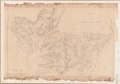 | 7,971 × 5,585 (127.37 MB) | Fæ (talk | contribs) | LOC Maps https://www.loc.gov/item/77693822/ #118 |
You cannot overwrite this file.
File usage on Commons
The following page uses this file: