File:Map SLH-1650.png
Size of this preview: 603 × 600 pixels. Other resolutions: 241 × 240 pixels | 483 × 480 pixels | 900 × 895 pixels.
Original file (900 × 895 pixels, file size: 345 KB, MIME type: image/png)
Captions
Captions
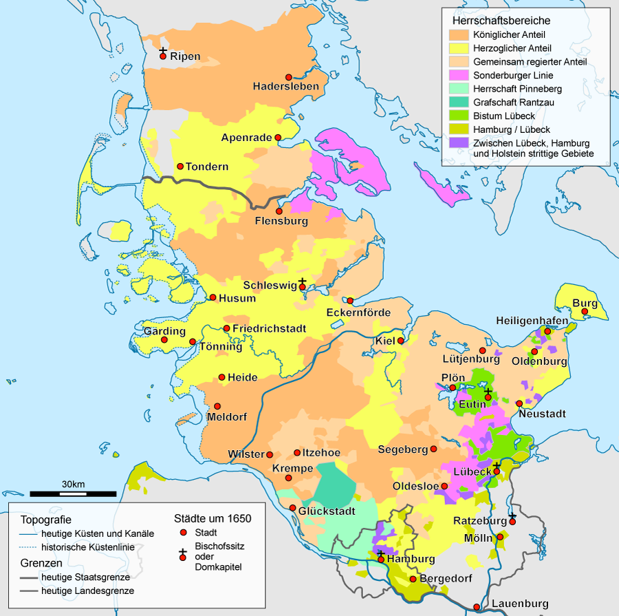
Political map of Schleswig-Holstein after 1650
Summary edit
| Description |
English: Map of Schleswig-Holstein after 1650 |
| Date | |
| Source | File:Schleswig-Holstein location map.svg, de:Grafschaft Rantzau, File:Denmark_location_map.svg, http://www.geschichte-s-h.de, Ulrich Lange (Hrsg.): Geschichte Schleswig-Holsteins von den Anfängen bis zur Gegenwart. 2. Auflage 2003, Wachholtz, Neumünster. S.: 133 |
| Author | Begw mit tatkräftiger Unterstützung durch de:Benutzer:PodracerHH |
| Other versions |
  |
Licensing edit
I, the copyright holder of this work, hereby publish it under the following licenses:

|
Permission is granted to copy, distribute and/or modify this document under the terms of the GNU Free Documentation License, Version 1.2 or any later version published by the Free Software Foundation; with no Invariant Sections, no Front-Cover Texts, and no Back-Cover Texts. A copy of the license is included in the section entitled GNU Free Documentation License. |
This file is licensed under the Creative Commons Attribution-Share Alike 3.0 Unported license.
- You are free:
- to share – to copy, distribute and transmit the work
- to remix – to adapt the work
- Under the following conditions:
- attribution – You must give appropriate credit, provide a link to the license, and indicate if changes were made. You may do so in any reasonable manner, but not in any way that suggests the licensor endorses you or your use.
- share alike – If you remix, transform, or build upon the material, you must distribute your contributions under the same or compatible license as the original.
You may select the license of your choice.
File history
Click on a date/time to view the file as it appeared at that time.
| Date/Time | Thumbnail | Dimensions | User | Comment | |
|---|---|---|---|---|---|
| current | 16:21, 23 May 2014 | | 900 × 895 (345 KB) | Kopiersperre (talk | contribs) | optipng |
| 16:25, 1 January 2010 |  | 900 × 895 (401 KB) | Begw (talk | contribs) | war die falsche | |
| 16:15, 1 January 2010 |  | 900 × 895 (299 KB) | Begw (talk | contribs) | neuer versuch | |
| 16:13, 1 January 2010 |  | 900 × 895 (401 KB) | Begw (talk | contribs) | Korrektur Amrum und Föhr | |
| 07:13, 30 April 2009 |  | 900 × 895 (401 KB) | Begw (talk | contribs) | argh! | |
| 07:12, 30 April 2009 |  | 900 × 895 (395 KB) | Begw (talk | contribs) | kleine korrektur | |
| 06:32, 30 April 2009 |  | 900 × 895 (401 KB) | Begw (talk | contribs) | new version | |
| 17:02, 29 April 2009 |  | 900 × 895 (395 KB) | Begw (talk | contribs) | new version | |
| 07:57, 29 April 2009 |  | 900 × 895 (395 KB) | Begw (talk | contribs) | {{Information |Description={{en|1=Map of Schleswig-Holstein after 1650}} |Source=Datei:Schleswig-Holstein location map.svg, Grafschaft Rantzau, Datei:Denmark_location_map.svg, [http://www.geschichte-s-h.de/vonabisz/bilder/gottorf3_600.gif ht |
You cannot overwrite this file.
File usage on Commons
The following 3 pages use this file:
File usage on other wikis
The following other wikis use this file:
- Usage on bg.wikipedia.org
- Usage on cs.wikipedia.org
- Usage on da.wikipedia.org
- Usage on de.wikipedia.org
- Schleswig-Holstein
- Herzogtum Schleswig
- Deutsche Minderheit in Dänemark
- Schleswig-Holstein-Gottorf
- Südschleswig
- Herzogtum Holstein
- Holstein-Pinneberg
- Adliges Gut
- Hochstift Lübeck
- Diskussion:Altona-Kieler Eisenbahn-Gesellschaft
- Schleswig-Holstein-Sonderburg
- Diskussion:Herzogtum Holstein
- Dänischer Gesamtstaat
- Postgeschichte und Briefmarken Schleswig-Holsteins
- Schleswig-Holstein-Sonderburg-Plön
- Up ewig ungedeelt
- Statthalter (Schleswig-Holstein)
- Benutzer:Begw/Spickzettel
- Infanterie-Regiment „Herzog von Holstein“ (Holsteinisches) Nr. 85
- Lübsche Güter
- Grafschaft Rantzau
- Wikipedia:Kartenwerkstatt/Archiv/2009-04
- Herrschaft Pinneberg
- Wikipedia:Kartenwerkstatt/Karte des Tages/Galerie
- Holsteinfeldzug
- Amt Neumünster
- Usage on es.wikipedia.org
- Usage on et.wikipedia.org
- Usage on frr.wikipedia.org
- Usage on fr.wikipedia.org
- Usage on it.wikipedia.org
- Usage on ja.wikipedia.org
- Usage on nl.wikipedia.org
View more global usage of this file.