File:Map and views illustrating Sir Francis Drake's West Indian voyage, 1585-6 LOC 2007626708-3.jpg

Size of this preview: 778 × 599 pixels. Other resolutions: 312 × 240 pixels | 623 × 480 pixels | 997 × 768 pixels | 1,280 × 986 pixels | 2,560 × 1,973 pixels | 6,677 × 5,145 pixels.
Original file (6,677 × 5,145 pixels, file size: 5.53 MB, MIME type: image/jpeg)
Captions
Captions
Add a one-line explanation of what this file represents
Summary edit
| Description |
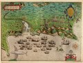
English: The first engraving is a map of Drake's voyage [showing Europe, western Africa, northern South America, and eastern North America]; the four other engravings consist of bird's-eye battle plan views of the cities of Santiago, Santo Domingo, Cartagena, and St. Augustine, Florida. 4 bird's-eye views and 1 map. Relief shown pictorially on bird's-eye views. Voyage map in English; city maps in Latin. Title supplied by cataloger. Map and views created to illustrate Bigges' and Croftes' Summarie and true discourse of Sir Frances Drake's West Indian voyage, 1589. Provenance: Gift of Jay I. Kislak Foundation. Orientation varies. Kraus, H.P. Sir Francis Drake, p. 121-7 Available also through the Library of Congress Web site as a raster image. Includes hand col. ill. Select features alphabetically indexed on bird's-eye views, views not accompanied by index key. "The verso of each sheet is numbered in ink in an identical early hand "1 [through] 5" in the following sequence: 1. 'Voyadge', 2. S. Domingo, 3. Cartagena, 4. S. Augustine, 5. Santiago."--Auction catalog. All sheets vertically fold-lined at center. Kislak accession no. 1991.322.01.0003 Kislak accession no. 1991.322.02.0003 Kislak accession no. 1991.322.03.0003 Kislak accession no. 1991.322.04.0003 Kislak accession no. 1991.322.05.0003 |
||
| Title | [Map and views illustrating Sir Francis Drake's West Indian voyage, 1585-6]. | ||
| Shelf ID | G3291.S12 s000 .B6 | ||
| Parent | https://www.loc.gov/resource/g3291sm.grb00002/ | ||
| Sheet title | Santiago | ||
| Date | 158509 d158607 | ||
| Source | https://www.loc.gov/item/2007626708/ | ||
| Author | Boazio, Baptista; Bigges, Walter; Croftes; Jay I. Kislak Collection (Library Of Congress) | ||
| Permission (Reusing this file) |
|
||
| Other versions |
|
||
| Location | Santo Domingo (Dominican Republic) · Saint Augustine (Fla.) · Great Britain · Western Hemisphere · West Indies · São Tiago Island (Cabo Verde) · Cartagena (Colombia) | ||
| Part of | Rare Book And Special Collections Division · General Maps · Catalog · American Memory · Rare Book Selections · Geography And Map Division | ||
| Subject | Aerial Views · Drake, Francis · United States · Cabo Verde · Early Works To 1800 · Colombia · São Tiago Island · Cartagena · Travel · Santo Dominigo · Maps · Saint Augustine · History, Naval · Santo Domingo (Dominican Republic) · Saint Augustine (Fla.) · Great Britain · Tudors · Discovery And Exploration · West Indies Expedition · Florida · Western Hemisphere · West Indies · São Tiago Island (Cabo Verde) · Dominican Republic · Cartagena (Colombia) |

Licensing edit
|
This is a faithful photographic reproduction of a two-dimensional, public domain work of art. The work of art itself is in the public domain for the following reason:
The official position taken by the Wikimedia Foundation is that "faithful reproductions of two-dimensional public domain works of art are public domain".
This photographic reproduction is therefore also considered to be in the public domain in the United States. In other jurisdictions, re-use of this content may be restricted; see Reuse of PD-Art photographs for details. | ||||
File history
Click on a date/time to view the file as it appeared at that time.
| Date/Time | Thumbnail | Dimensions | User | Comment | |
|---|---|---|---|---|---|
| current | 04:50, 4 November 2018 | | 6,677 × 5,145 (5.53 MB) | Fæ (talk | contribs) | LOC Maps multisheet https://www.loc.gov/item/2007626708/ sheet 3 of 5 #5595 |
You cannot overwrite this file.
File usage on Commons
The following page uses this file: