File:Map exhibiting the route of communication between Philadelphia & Charleston LOC 98688345.jpg

Size of this preview: 800 × 589 pixels. Other resolutions: 320 × 236 pixels | 640 × 471 pixels | 1,024 × 754 pixels | 1,280 × 942 pixels | 2,560 × 1,884 pixels | 6,885 × 5,067 pixels.
Original file (6,885 × 5,067 pixels, file size: 4.92 MB, MIME type: image/jpeg)
Captions
Captions
Add a one-line explanation of what this file represents
Summary
edit| Description |
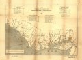
English: Three rail and canal route distances are tabulated and one steamboat route. The legend indicates "Rail Road route," "Canal route," and "Steamboat route." Shows coastal area between Philadelphia, Pa., and Charleston, S.C., indicating larger cities and rivers. |
||
| Title | Map exhibiting the route of communication between Philadelphia & Charleston | ||
| Shelf ID | G3709.31.P1 1837 .M35 | ||
| Date | |||
| Source | https://www.loc.gov/item/98688345/ | ||
| Author | Mcclellan, John | ||
| Permission (Reusing this file) |
|
||
| Other versions |
|
||
| Location | United States · Atlantic States | ||
| Part of | American Memory · Catalog · Railroad Maps, 1828-1900 · Geography And Map Division · Transportation And Communication | ||
| Subject | United States · Maps · Transportation · Atlantic States |

Licensing
edit
|
This is a faithful photographic reproduction of a two-dimensional, public domain work of art. The work of art itself is in the public domain for the following reason:
The official position taken by the Wikimedia Foundation is that "faithful reproductions of two-dimensional public domain works of art are public domain".
This photographic reproduction is therefore also considered to be in the public domain in the United States. In other jurisdictions, re-use of this content may be restricted; see Reuse of PD-Art photographs for details. | ||||
File history
Click on a date/time to view the file as it appeared at that time.
| Date/Time | Thumbnail | Dimensions | User | Comment | |
|---|---|---|---|---|---|
| current | 09:55, 24 May 2018 | | 6,885 × 5,067 (4.92 MB) | Fæ (talk | contribs) | LOC Maps https://www.loc.gov/item/98688345/ #127 |
You cannot overwrite this file.
File usage on Commons
The following page uses this file: