File:Map of Mississippi, Louisiana and Arkansas WDL9599.png

Size of this preview: 444 × 599 pixels. Other resolutions: 178 × 240 pixels | 356 × 480 pixels | 569 × 768 pixels | 1,024 × 1,382 pixels.
Original file (1,024 × 1,382 pixels, file size: 2.47 MB, MIME type: image/png)
Captions
Captions
Add a one-line explanation of what this file represents
Summary
edit
| Author |
Русский: Бурр, Дэвид Г., 1803-1875 гг.
Français : Burr, David H., 1803-1875
English: Burr, David H., 1803-1875
中文:大卫·伯尔,1803-1875 年
Português: Burr, David H., 1803-1875
العربية: ديفيد بور، 1803-1875
Español: Burr, David H., 1803-1875 |
| Title |
Русский: Карта штатов Миссисипи, Луизиана и Арканзас
Français : Carte du Mississippi, de la Louisiane et de l'Arkansas
English: Map of Mississippi, Louisiana and Arkansas
中文:密西西比州、路易斯安那州和阿肯色州地图
Português: Mapa do Mississippi, da Louisiana e do Arkansas
العربية: خريطة ميسيسيبي ولويزيانا وأركنساس
Español: Mapa de Mississippi, Luisiana y Arkansas |
| Description |
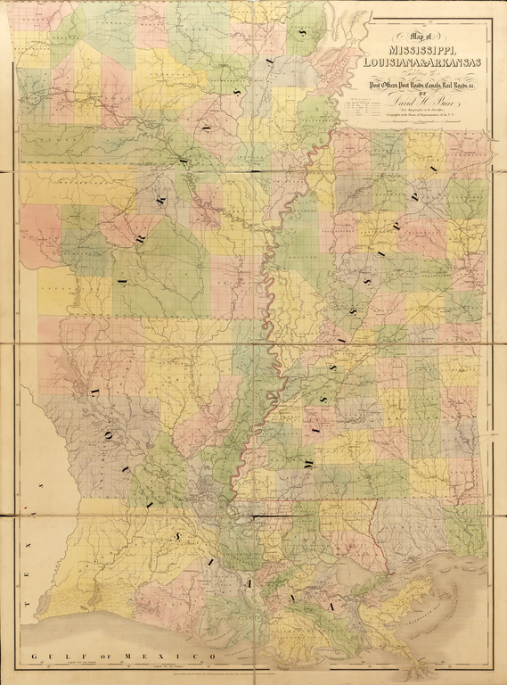
Русский: Дэвид Г. Бурр (1803–1875 гг.), землемер и картограф, служил топографом Почтового департамента США в 1832–1838 гг. и географом Палаты представителей в 1838–1847 гг. Под руководством генерального почтмейстера Бурр собирал от почтмейстеров всей страны информацию о транспортных маршрутах – почтовых трактах, железных дорогах и каналах, а также о расположении почтовых отделений с целью выпуска большого комплекта государственных и региональных карт. Опубликованный в 1839 г. известной лондонской картографической фирмой Джона Эрроусмита, "Американский атлас" Бурра представлял подробную картину заселения и транспортных маршрутов в Соединенных Штатах Америки за несколько десятилетий до Гражданской войны. Здесь представлена составленная Бурром карта штатов Миссисипи, Луизиана и Арканзас, одна из 13 карт атласа. 30 апреля 1812 г. Луизиана стала 18-м штатом США (и первым штатом, выделенным из территории Луизиана, приобретенной у Франции в 1803 г.). Территория Миссисипи была принята в состав Союза в качестве 20-го штата 10 декабря 1817 г. Арканзас был организован как территория в 1819 г. и стал 25-м штатом 15 июня 1836 г. Три штата были связаны экономически важной коммуникацией, рекой Миссисипи. За важным исключением в виде космополитического портового города, Нового Орлеана, все три штата были преимущественно сельскохозяйственными и имели малое количество крупных и небольших городов.
Каналы; Река Миссисипи; Почтовые тракты; Почтовая служба; Железные дороги Français : Géomètre et cartographe, David H. Burr (1803-1875) fut topographe au Département des Postes des États-Unis entre 1832 et 1838, puis géographe à la Chambre des représentants entre 1838 et 1847. Sous la direction du Maître des postes général, Burr compila les informations fournies par les maîtres des postes à travers le pays concernant les routes (routes postières, chemins de fer et cours d'eau) et l'emplacement des bureaux de poste afin de réaliser une importante série de cartes des États et des régions. Publié en 1839 par l'éminente société cartographique de John Arrowsmith, L'atlas américain de Burr représente de façon détaillée la répartition du peuplement et du transport aux États-Unis quelques dizaines d'années avant la guerre de Sécession. La carte de Burr exposée ici représentant le Mississippi, la Louisiane et l'Arkansas fait partie des 13 cartes de l'atlas. Le 30 avril 1812, la Louisiane devint le 18e État des États-Unis (et le premier provenant de la division du Territoire de Louisiane acheté à la France en 1803). Le Mississippi fut intégré à l'Union comme 20e État le 10 décembre 1817. L'Arkansas fut organisé en territoire en 1819, puis devint le 25e État le 15 juin 1836. Les trois États étaient liés par la source essentielle de leur économie, le fleuve Mississippi. À l'exception notable de la ville portuaire cosmopolite de La Nouvelle-Orléans, les trois États étaient en grande majorité ruraux et ne se composaient que d'un petit nombre de villes et grandes villes.
Canaux; Fleuve Mississippi; Routes postières; Service postal; Chemins de fer English: David H. Burr (1803–75) was a surveyor and cartographer, who served as topographer to the United States Post Office Department in 1832–38 and as geographer to the House of Representatives in 1838–47. Under the direction of the postmaster general, Burr compiled information from postmasters throughout the country about transportation routes—post roads, railroads, and canals—and the location of post offices to produce a large set of state and regional maps. Published in 1839 by the prominent London mapmaking firm of John Arrowsmith, Burr’s The American Atlas offers a detailed picture of settlement and transportation patterns in the United States in the decades before the Civil War. Shown here is Burr’s map of Mississippi, Louisiana, and Arkansas, one of 13 maps in the atlas. On April 30, 1812, Louisiana became the 18th U.S. state (and the first carved out of the Louisiana Territory purchased from France in 1803). Mississippi was admitted to the Union as the 20th state on December 10, 1817. Arkansas was organized as a territory in 1819 and became the 25th state on June 15, 1836. The three states were tied together by their economic lifeline, the Mississippi River. With the significant exception of the cosmopolitan port city of New Orleans, all three states were overwhelmingly rural and had few large cities or towns.
Canals; Mississippi River; Post roads; Postal service; Railroads 中文:大卫·伯尔(David H. Burr,1803-1875 年)是一位测量员和制图员,于 1832—1838 年担任美国邮政署地形学者,1838—1847 年担任众议院地理学家。在邮政署长的指导下,伯尔汇编了全国各地邮政局长提供的有关运输路线(邮路、铁路和运河)以及邮局位置的信息,制作了大量州地图和地区地图。伯尔的 《美国地图册》由伦敦著名制图商约翰·阿罗史密斯 (John Arrowsmith) 于 1839 年出版,详细描绘了美国在内战前数十年的聚居和运输模式。这里展示的是伯尔地图册中的 13 幅地图之一——密西西比州、路易斯安那州和阿肯色州地图。1812 年 4 月 30 日,路易斯安那州成为美国第 18 个州(美国于 1803 年从法国购得路易斯安那领地)。1817 年 12 月 10 日,密西西比州加入联邦,成为第 20 个州。1819 年,阿肯色成为建制领土,1836 年 6 月 15 日,阿肯色成为第 25 个州。这三个州被它们的经济命脉密西西比河联结在一起。除国际化港口城市新奥尔良外,三个州均以农村为主,少有大型市镇。
运河; 密西西比河; 邮路; 邮政服务; 铁路 Português: David H. Burr (1803-1875) foi um agrimensor e cartógrafo, que atuou como topógrafo para o Departamento de Correios dos Estados Unidos entre 1832 e 1838 e como geógrafo para a Câmara dos Representantes entre 1838 e 1847. Sob a direção do reponsável geral dos correios, Burr compilou informações dos responsáveis dos correios em todo o país sobre rotas de transporte—estradas de correios, ferrovias e canais—e o local dos postos de correios para a produção de um grande conjunto de mapas estaduais e regionais. Publicado em 1839 pela proeminente empresa de cartografia londrina de John Arrowsmith, O atlas americano de Burr fornece um quadro detalhado da disposição das colônias e do transporte nos Estados Unidos nas décadas anteriores à Guerra Civil. Aqui é mostrado o mapa de Burr do Mississippi, da Louisiana e do Arkansas, um dos 13 mapas do atlas. Em 30 de abril de 1812, a Louisiana tornou-se o 18º estado dos Estados Unidos (e o primeiro estabelecido fora do território da Louisiana, adquirido da França em 1803). Mississippi foi incorporado à União como o 20º estado em 10 de dezembro de 1817. Arkansas foi organizado como um território em 1819 e tornou-se o 25º estado em 15 de junho de 1836. Os três estados foram unidos por sua salvação econômica, o rio Mississippi. Com a honrosa exceção da cidade portuária cosmopolita de Nova Orleans, todos os três estados eram predominantemente rurais e tiveram poucas cidades grandes ou vilas.
Canais; Rio Mississippi; Estradas do correio; Serviço postal; Ferrovias العربية: كان ديفيد بور (1803-1875) ماسح أراضٍ ورسام خرائط، وقد شغل منصب طبوغرافي تابع لإدارة مكاتب البريد الأمريكية في الفترة ما بين 1832-1838، كما عَمِل جغرافياً تابعاً لمجلس النواب في الفترة ما بين 1838-1847. جمع بور معلومات من مدراء مكاتب البريد الموجودة في جميع أنحاء الدولة حول مسارات النقل— طرق نقل البريد والسكك الحديدية والقنوات— ومواقع مكاتب البريد لتصميم مجموعة كبيرة من خرائط الولايات والأقاليم، وذلك بتوجيه من المدير العام لمكتب البريد. نشرت مؤسسة جون آروسميث البارزة لصنع الخرائط بلندن الأطلس الأمريكي بقلم بور عام 1839، وهو يعرض صورة مفصلة لأنماط الاستيطان والنقل في الولايات المتحدة في العقود السابقة للحرب الأهلية. مبينة هنا خريطة ميسيسيبي ولويزيانا وأركنساس من تصميم بور، وهي واحدة من بين الخرائط الـ13 الموجودة بالأطلس. صارت لويزيانا الولاية الأمريكية رقم 18 (وأول ولاية يتم تأسيسها من مقاطعة لويزيانا المشتراة من فرنسا في 1803) في 30 أبريل عام 1812. تم ضم ميسيسيبي باعتبارها الولاية رقم 20 في 10 ديسمبر عام 1817. أُسِّست مقاطعة أركنساس في 1819، وصارت الولاية رقم 25 في 15 يونيو عام 1836. تم الوصل بين الولايات الثلاث عبر نهر الميسيسيبي، الذي كان لهم بمثابة الشريان الاقتصادي. كانت الولايات الثلاث ريفية ولم يكن بها إلا بضع مدن أو بلدات كبيرة، وذلك باستثناء نيو أورلينز، المدينة الساحلية العالمية الهامة.
القنوات; نهر ميسيسيبي; طرق نقل البريد; خدمات البريد; السكك الحديدية Español: David H. Burr (1803-1875) era topógrafo y cartógrafo, y se desempeñó como topógrafo en el Departamento de Correos de los Estados Unidos de 1832 a 1838 y como geógrafo para la Cámara de Representantes entre 1838 y 1847. Bajo la dirección del director general de correos, Burr recopiló información de los administradores de correo de todo el país acerca de las rutas de transporte (carreteras, ferrocarriles y canales de rutas de correos) y la ubicación de las oficinas de correos para producir un gran conjunto de mapas estatales y regionales. Publicado en 1839 por la prominente empresa de cartografía londinense de John Arrowsmith, El atlas estadounidense de Burr ofrece un panorama detallado de los patrones de asentamiento y el transporte en los Estados Unidos en las décadas anteriores a la Guerra Civil. Aquí se muestra el mapa de Burr de Mississippi, Luisiana y Arkansas: uno de los 13 mapas del atlas. El 30 de abril de 1812, Luisiana se convirtió en el decimoctavo estado de los EE. UU. (y la primera división del territorio de Luisiana, comprada Francia en 1803). El 10 de diciembre de 1817, Mississippi se convirtió en el vigésimo estado de la Unión. Arkansas se organizó como un territorio en 1819 y se convirtió en el vigésimo quinto estado el 15 de junio de 1836. Los tres estados estaban unidos por un mismo recurso económico: el río Mississippi. Con la notable excepción de la cosmopolita ciudad portuaria de Nueva Orleans, los tres estados eran abrumadoramente rurales y tenían pocas grandes ciudades.
Canales; Río Mississippi; Rutas de correos; Servicio postal; Ferrocarriles |
| Date | 1839 |
| Medium |
Русский: Карты
Français : Cartes
English: Maps
中文:地图
Português: Mapas
العربية: خرائط
Español: Mapas |
| Dimensions |
English: 1 map from loose-leaf atlas : hand colored, mounted on cloth ; 130 x 130 centimeters or smaller, folded in case 50 x 33 x 7 centimeters |
| Collection |
Русский: Библиотека Конгресса
Français : Bibliothèque du Congrès
English: Library of Congress
中文:国会图书馆
Português: Biblioteca do Congresso
العربية: مكتبة الكونغرس
Español: Biblioteca del Congreso |
| Place of creation |
Русский: Арканзас
Français : Arkansas
English: Arkansas
中文:阿肯色州
Português: Arkansas
العربية: أركنساس
Español: Arkansas |
| Source/Photographer |
|
Licensing
edit
|
This is a faithful photographic reproduction of a two-dimensional, public domain work of art. The work of art itself is in the public domain for the following reason:
The official position taken by the Wikimedia Foundation is that "faithful reproductions of two-dimensional public domain works of art are public domain".
This photographic reproduction is therefore also considered to be in the public domain in the United States. In other jurisdictions, re-use of this content may be restricted; see Reuse of PD-Art photographs for details. | ||||
File history
Click on a date/time to view the file as it appeared at that time.
| Date/Time | Thumbnail | Dimensions | User | Comment | |
|---|---|---|---|---|---|
| current | 04:12, 12 March 2014 | | 1,024 × 1,382 (2.47 MB) | Fæ (talk | contribs) | =={{int:filedesc}}== {{Artwork |artist = |author ={{ru|1=Бурр, Дэвид Г., 1803-1875 гг.}} {{fr|1=Burr, David H., 1803-1875}} {{en|1=Burr, David H., 1803-1875}} {{zh|1=大卫·伯尔,1803-1875 年}} {{pt|1=Burr, David H., 1803-1875}} {{ar|... |
You cannot overwrite this file.
File usage on Commons
The following page uses this file: