File:Map of Montgomery County, New York - from actual surveys LOC 2013593280.jpg

Size of this preview: 800 × 442 pixels. Other resolutions: 320 × 177 pixels | 640 × 353 pixels | 1,024 × 566 pixels | 1,280 × 707 pixels | 2,560 × 1,414 pixels | 19,552 × 10,798 pixels.
Original file (19,552 × 10,798 pixels, file size: 30.3 MB, MIME type: image/jpeg)
Captions
Captions
Add a one-line explanation of what this file represents
Summary edit
| Warning | The original file is very high-resolution. It might not load properly or could cause your browser to freeze when opened at full size. |
|---|
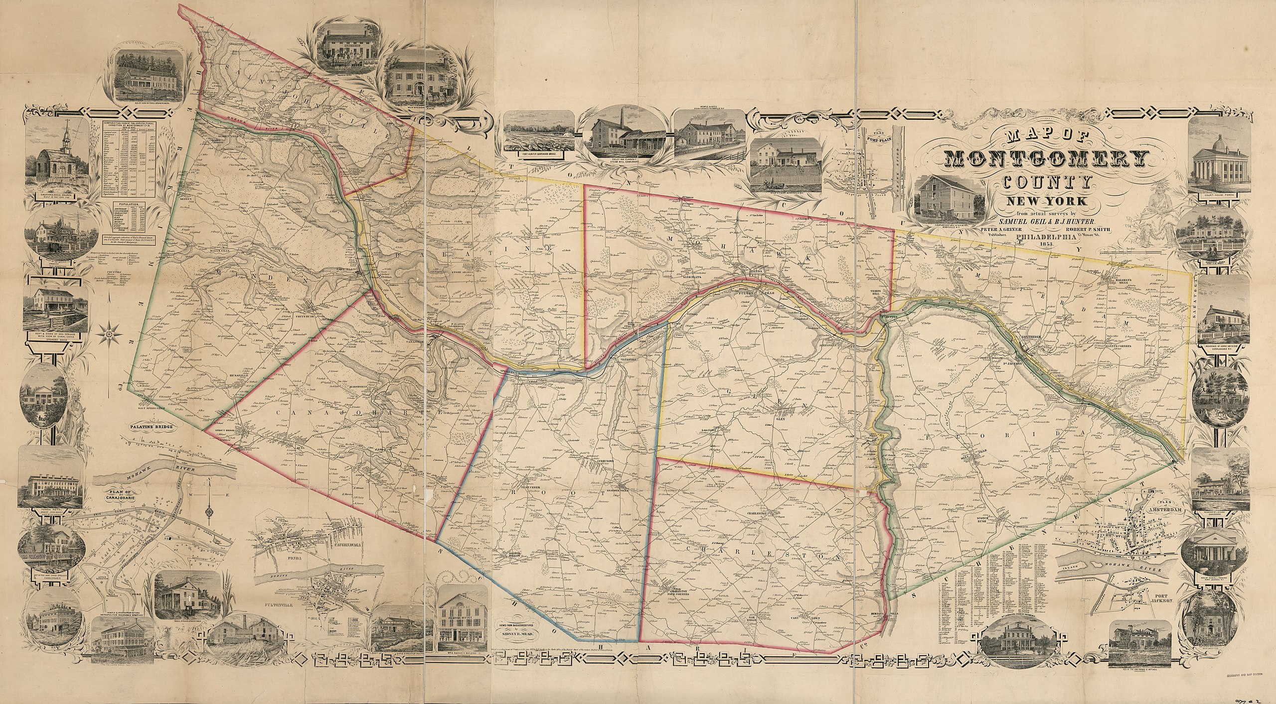
| Description |
English: General-content county map showing towns (townships), rural buildings, and householders' names. Relief shown by hachures. Hand colored to emphasize town boundaries. "Entered according to act of Congress in the year 1853 by R.P. Smith in the ... eastern District of Pennsylvania." Originally printed on 2 sheets (later conjoined). LC copy imperfect: Mounted on cloth backing, torn (before mounting), fold-lined, sheets thirded to enable folding. LC Land ownership maps, 521 Includes notes, 4 small-town/village insets (including Amsterdam and Canajoharie), index of Amsterdam building occupants' names, 2 statistical tables, and illustrations of prominent buildings. Available also through the Library of Congress Web site as a raster image. 2 copies |
||
| Title | Map of Montgomery County, New York : from actual surveys | ||
| Shelf ID | G3803.M7 1853 .G4 G3803.M7 1853 .G4 | ||
| Date | |||
| Source | https://www.loc.gov/item/2013593280/ | ||
| Author | Geil, Samuel; Hunter, J.; Griner, Peter A.; Smith, Robert Pearsall | ||
| Permission (Reusing this file) |
|
||
| Other versions |
|
||
| Location | United States · Canajoharie · New York · Montgomery County · Amsterdam · New York (State) | ||
| Part of | American Memory · Catalog · County Landownership Maps · Geography And Map Division · Cultural Landscapes | ||
| Subject | Amsterdam (N.Y.) · Canajoharie (N.Y.) · Cities And Towns · Villages · Montgomery County (N.Y.) · United States · Maps · Canajoharie · Montgomery County · Amsterdam · New York (State) · Landowners |


Licensing edit
|
This is a faithful photographic reproduction of a two-dimensional, public domain work of art. The work of art itself is in the public domain for the following reason:
The official position taken by the Wikimedia Foundation is that "faithful reproductions of two-dimensional public domain works of art are public domain".
This photographic reproduction is therefore also considered to be in the public domain in the United States. In other jurisdictions, re-use of this content may be restricted; see Reuse of PD-Art photographs for details. | ||||
File history
Click on a date/time to view the file as it appeared at that time.
| Date/Time | Thumbnail | Dimensions | User | Comment | |
|---|---|---|---|---|---|
| current | 23:05, 2 June 2018 | | 19,552 × 10,798 (30.3 MB) | Fæ (talk | contribs) | LOC Maps https://www.loc.gov/item/2013593280/ #18330 |
You cannot overwrite this file.
File usage on Commons
The following page uses this file: