File:Map of Philadelphia County - constructed by virtue of an act of the Legislature of Pennsylvania passed 19th March 1816 LOC 79695293.tif

Size of this JPG preview of this TIF file: 665 × 599 pixels. Other resolutions: 266 × 240 pixels | 533 × 480 pixels | 852 × 768 pixels | 1,136 × 1,024 pixels | 2,272 × 2,048 pixels | 5,927 × 5,342 pixels.
Original file (5,927 × 5,342 pixels, file size: 90.59 MB, MIME type: image/tiff)
Captions
Captions
Add a one-line explanation of what this file represents
Summary
edit| Description |
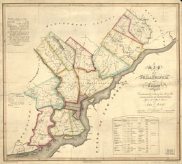
English: Scale 1:79,200; 1 1/4 miles to an in. Hand colored. LC copy annotated in pencil. Relief shown by hachures. Depths shown by soundings. Reference meridian: Washington. Shows land owners' names in rural areas. LC Land ownership maps, no. 783 Includes "Remarks, statistical and geological" and "Statistical table." Available also through the Library of Congress Web site as a raster image. Vault AACR2 |
||
| Title | Map of Philadelphia County : constructed by virtue of an act of the Legislature of Pennsylvania passed 19th March 1816 | ||
| Shelf ID | G3824.P5 1819 .M4 | ||
| Date | |||
| Source | https://www.loc.gov/item/79695293/ | ||
| Author | Melish, John; Tanner, Vallance, Kearny & Co. | ||
| Permission (Reusing this file) |
|
||
| Other versions |
|
||
| Location | Pennsylvania · United States · Philadelphia | ||
| Part of | American Memory · Catalog · County Landownership Maps · Geography And Map Division · Cultural Landscapes | ||
| Subject | Pennsylvania · Philadelphia (Pa.) · Philadelphia · United States · Maps · Real Property |


Licensing
edit|
This is a faithful photographic reproduction of a two-dimensional, public domain work of art. The work of art itself is in the public domain for the following reason:
The official position taken by the Wikimedia Foundation is that "faithful reproductions of two-dimensional public domain works of art are public domain".
This photographic reproduction is therefore also considered to be in the public domain in the United States. In other jurisdictions, re-use of this content may be restricted; see Reuse of PD-Art photographs for details. | ||||
File history
Click on a date/time to view the file as it appeared at that time.
| Date/Time | Thumbnail | Dimensions | User | Comment | |
|---|---|---|---|---|---|
| current | 17:17, 7 June 2018 |  | 5,927 × 5,342 (90.59 MB) | Fæ (talk | contribs) | LOC Maps https://www.loc.gov/item/79695293/ #22951 |
You cannot overwrite this file.
File usage on Commons
The following page uses this file: