File:Map of Ulster Co., New York - from actual surveys LOC 2013593238.jpg

Size of this preview: 597 × 600 pixels. Other resolutions: 239 × 240 pixels | 478 × 480 pixels | 765 × 768 pixels | 1,019 × 1,024 pixels | 2,039 × 2,048 pixels | 17,804 × 17,883 pixels.
Original file (17,804 × 17,883 pixels, file size: 47.65 MB, MIME type: image/jpeg)
Captions
Captions
Add a one-line explanation of what this file represents
Summary
edit| Warning | The original file is very high-resolution. It might not load properly or could cause your browser to freeze when opened at full size. |
|---|
| Description |
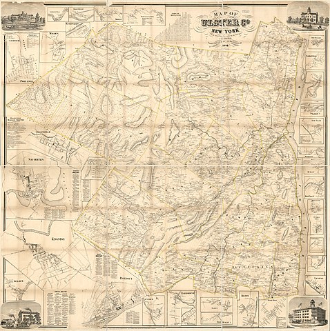
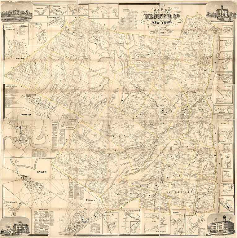
English: County map showing towns (townships), town allotment subdivisions, principal land ownership tracts (numbered), rural buildings, and householders' names. The inset maps of Kingston, Ellenville, and Saugerties show buildings (mostly not identified) and lot/tract lines. Relief shown by hachures. Hand colored in yellow to emphasize town (township) boundaries. "Entered according to Act of Congress by Robert P. Smith in the year 1858 ... for the Eastern District of Pennsylvania." Mounted on backing to form northern/southern segments. Originally printed on 6 sheets (later conjoined). LC copy imperfect: Trimmed at outer edges before mounting, both sheets thirded to enable folding. LC Land ownership maps, 571 Includes distance table, local business directories, 31 small-town/village insets, and illustrations of prominent buildings. Available also through the Library of Congress Web site as a raster image. 3 copies |
||
| Title | Map of Ulster Co., New York : from actual surveys | ||
| Shelf ID | G3803.U4G46 1858 .F7 G3803.U4G46 1858 .F7 Copy 2 G3803.U4G46 1858 .F7 Copy 3 | ||
| Date | |||
| Source | https://www.loc.gov/item/2013593238/ | ||
| Author | French, J. H. (John Homer); Dawson, L. G.; Smith, Robert Pearsall; Taintor, Dawson & Co.; French, J. H. | ||
| Permission (Reusing this file) |
|
||
| Location | Saugerties · Kingston · Ulster County · United States · New York · New York (State) · Ellenville | ||
| Part of | American Memory · Catalog · County Landownership Maps · Geography And Map Division · Cultural Landscapes | ||
| Subject | Cadastral Maps · Villages · Saugerties · Cities And Towns · Kingston · Ulster County · Ulster County (N.Y.) · United States · Maps · Kingston (N.Y.) · Ellenville (N.Y.) · Real Property · New York (State) · Landowners · Ellenville · Saugerties (N.Y.) |

Licensing
edit
|
This is a faithful photographic reproduction of a two-dimensional, public domain work of art. The work of art itself is in the public domain for the following reason:
The official position taken by the Wikimedia Foundation is that "faithful reproductions of two-dimensional public domain works of art are public domain".
This photographic reproduction is therefore also considered to be in the public domain in the United States. In other jurisdictions, re-use of this content may be restricted; see Reuse of PD-Art photographs for details. | ||||
File history
Click on a date/time to view the file as it appeared at that time.
| Date/Time | Thumbnail | Dimensions | User | Comment | |
|---|---|---|---|---|---|
| current | 10:19, 16 May 2018 | | 17,804 × 17,883 (47.65 MB) | Fæ (talk | contribs) | LOC Maps https://www.loc.gov/item/2013593238/ #1013 |
You cannot overwrite this file.
File usage on Commons
There are no pages that use this file.