File:Map of cavalry engagement near Bridgewater, Va., Oct. 4th and 5th, 1864 LOC 2005625100.tif

Size of this JPG preview of this TIF file: 482 × 599 pixels. Other resolutions: 193 × 240 pixels | 386 × 480 pixels | 618 × 768 pixels | 824 × 1,024 pixels | 2,435 × 3,025 pixels.
Original file (2,435 × 3,025 pixels, file size: 21.07 MB, MIME type: image/tiff)
Captions
Captions
Add a one-line explanation of what this file represents
Summary edit
| Description |
English: Relief shown by hachures. Title from Stephenson's Civil War maps, 1989. Pen-and-ink on verso of lined paper, mounted on cloth. Similar to the map reproduced in the Atlas to accompany the official records of the Union and Confederate Armies, 1891-95, pl. 82, no. 12. LC Civil War maps (2nd ed.), H193 Available also through the Library of Congress web site as raster image. In pencil on verso: 451. |
||
| Title | [Map of cavalry engagement near Bridgewater, Va., Oct. 4th and 5th, 1864 | ||
| Shelf ID | G3884.B78S5 1864 .H6 | ||
| Date | |||
| Source | https://www.loc.gov/item/2005625100/ | ||
| Author | Hotchkiss, Jedediah | ||
| Permission (Reusing this file) |
|
||
| Other versions |
|
||
| Location | United States · Bridgewater · Virginia | ||
| Part of | Civil War Maps · Hotchkiss Map Collection · Military Battles And Campaigns · Catalog · American Memory · Geography And Map Division | ||
| Subject | Maps, Manuscript · Bridgewater · Virginia · Civil War · United States · Bridgewater (Va.) · History |


Licensing edit
|
This is a faithful photographic reproduction of a two-dimensional, public domain work of art. The work of art itself is in the public domain for the following reason:
The official position taken by the Wikimedia Foundation is that "faithful reproductions of two-dimensional public domain works of art are public domain".
This photographic reproduction is therefore also considered to be in the public domain in the United States. In other jurisdictions, re-use of this content may be restricted; see Reuse of PD-Art photographs for details. | ||||
File history
Click on a date/time to view the file as it appeared at that time.
| Date/Time | Thumbnail | Dimensions | User | Comment | |
|---|---|---|---|---|---|
| current | 15:00, 17 May 2018 | 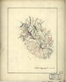 | 2,435 × 3,025 (21.07 MB) | Fæ (talk | contribs) | LOC Maps https://www.loc.gov/item/2005625100/ #10254 |
You cannot overwrite this file.
File usage on Commons
The following 3 pages use this file: