File:Map of siege of Fort Pulaski - Savannah River Georgia. 1862. LOC gvhs01.vhs00085.jpg

Size of this preview: 800 × 593 pixels. Other resolutions: 320 × 237 pixels | 640 × 474 pixels | 1,024 × 759 pixels | 1,280 × 949 pixels | 2,164 × 1,604 pixels.
Original file (2,164 × 1,604 pixels, file size: 602 KB, MIME type: image/jpeg)
Captions
Captions
Add a one-line explanation of what this file represents
Summary
edit| Description |
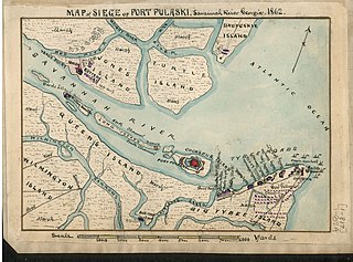
English: Shows the location of Jones Island, Turtle Island and Daufuskie Island on the north edge of the Savannah River and Querns Island, Wilmington Island and Big Tybee Island to the south, also indicated is the location of Fort Pulaski on Cockspur Island in the middle of the Savannah River. |
||
| Title | Map of siege of Fort Pulaski : Savannah River Georgia. 1862. | ||
| Shelf ID | https://www.loc.gov/item/001-CABIB20006104/ | ||
| Date | |||
| Source | https://www.loc.gov/item/gvhs01.vhs00085/ | ||
| Author | Sneden, Robert Knox | ||
| Permission (Reusing this file) |
|
||
| Other versions |
|
||
| Location | Savannah River · United States · Georgia · Fort Pulaski · South Carolina | ||
| Part of | Military Battles And Campaigns · American Memory · Civil War Maps · Geography And Map Division | ||
| Subject | Savannah River · Georgia · Fort Pulaski (Ga.) · Siege · Civil War · Savannah River (Ga. And S.C.) · United States · Maps · Fort Pulaski · History |


Licensing
edit
|
This is a faithful photographic reproduction of a two-dimensional, public domain work of art. The work of art itself is in the public domain for the following reason:
The official position taken by the Wikimedia Foundation is that "faithful reproductions of two-dimensional public domain works of art are public domain".
This photographic reproduction is therefore also considered to be in the public domain in the United States. In other jurisdictions, re-use of this content may be restricted; see Reuse of PD-Art photographs for details. | ||||
File history
Click on a date/time to view the file as it appeared at that time.
| Date/Time | Thumbnail | Dimensions | User | Comment | |
|---|---|---|---|---|---|
| current | 23:31, 8 July 2018 | | 2,164 × 1,604 (602 KB) | Fæ (talk | contribs) | LOC Maps https://www.loc.gov/item/gvhs01.vhs00085/ #545 |
You cannot overwrite this file.
File usage on Commons
The following page uses this file: