File:Map of the United States, the British provinces, Mexico etc. - showing the routes of the U.S. mail steam packets to California, and a plan of the Gold Region LOC 2012593336.tif
Size of this JPG preview of this TIF file: 718 × 599 pixels. Other resolutions: 288 × 240 pixels | 575 × 480 pixels | 920 × 768 pixels | 1,227 × 1,024 pixels | 2,454 × 2,048 pixels | 7,774 × 6,488 pixels.
Original file (7,774 × 6,488 pixels, file size: 144.3 MB, MIME type: image/tiff)
Captions
Captions
Add a one-line explanation of what this file represents
Summary edit
| Description |
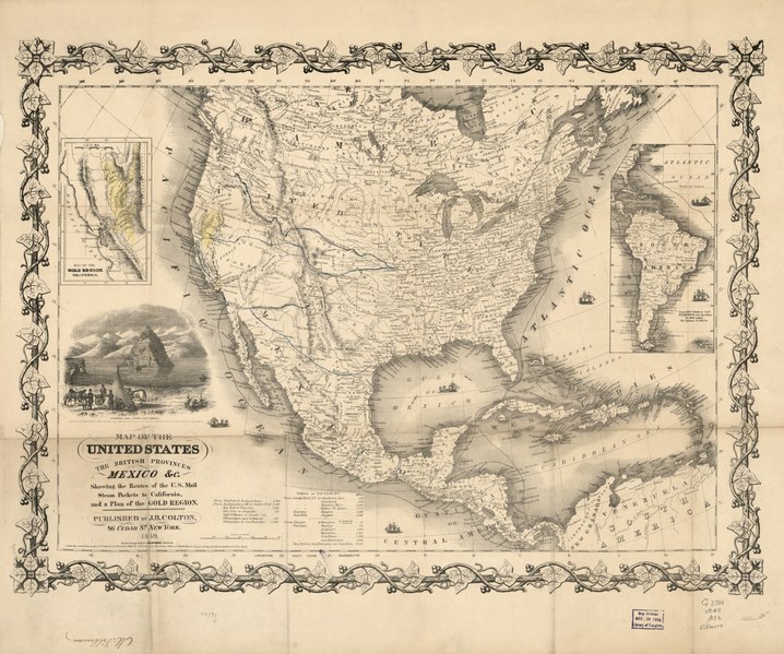
English: Relief shown by hachures. Shows California's gold region and western trails. "Entered according to Act of Congress in the year 1849 by J. H. Colton in the Clerks Office of the District Court of the Southern District of New York." Includes illustration of "Pyramid Lake, Upper California" and distance table. Insets: From New York to San Francisco via Cape Horn -- Map of the Gold Region, California. LC copy: Signed in lower margin: M. Fillmore. Mounted on cloth. LC Trails, 51 Available also through the Library of Congress Web site as a raster image. |
||
| Title | Map of the United States, the British provinces, Mexico &c. : showing the routes of the U.S. mail steam packets to California, and a plan of the Gold Region | ||
| Shelf ID | G3700 1849 .A72 G3700 1849 .A72 Copy 2 G3700 1849 .A72 Copy 3 | ||
| Date | |||
| Source | https://www.loc.gov/item/2012593336/ | ||
| Author | Atwood, John M. | ||
| Permission (Reusing this file) |
|
||
| Other versions |
|
||
| Location | United States · United States. | ||
| Part of | American Memory · General Maps · Catalog · Transportation And Communication · Geography And Map Division | ||
| Subject | United States · Maps |


Licensing edit
|
This is a faithful photographic reproduction of a two-dimensional, public domain work of art. The work of art itself is in the public domain for the following reason:
The official position taken by the Wikimedia Foundation is that "faithful reproductions of two-dimensional public domain works of art are public domain".
This photographic reproduction is therefore also considered to be in the public domain in the United States. In other jurisdictions, re-use of this content may be restricted; see Reuse of PD-Art photographs for details. | ||||
File history
Click on a date/time to view the file as it appeared at that time.
| Date/Time | Thumbnail | Dimensions | User | Comment | |
|---|---|---|---|---|---|
| current | 20:51, 21 May 2018 |  | 7,774 × 6,488 (144.3 MB) | Fæ (talk | contribs) | LOC Maps https://www.loc.gov/item/2012593336/ #13006 |
You cannot overwrite this file.
File usage on Commons
The following page uses this file: