File:Map of the country embracing the various routes surveyed for the Western & Atlantic Rail Road of Georgia, under the direction of Lieut. Col. S. H. Long, Chief Engineer, 1837, U.S. Topographical Bureau LOC 98688853.jpg
Size of this preview: 800 × 284 pixels. Other resolutions: 320 × 114 pixels | 640 × 227 pixels | 1,024 × 363 pixels | 1,280 × 454 pixels | 2,560 × 908 pixels | 6,493 × 2,304 pixels.
Original file (6,493 × 2,304 pixels, file size: 2.89 MB, MIME type: image/jpeg)
Captions
Captions
Add a one-line explanation of what this file represents
Summary
edit| Description |
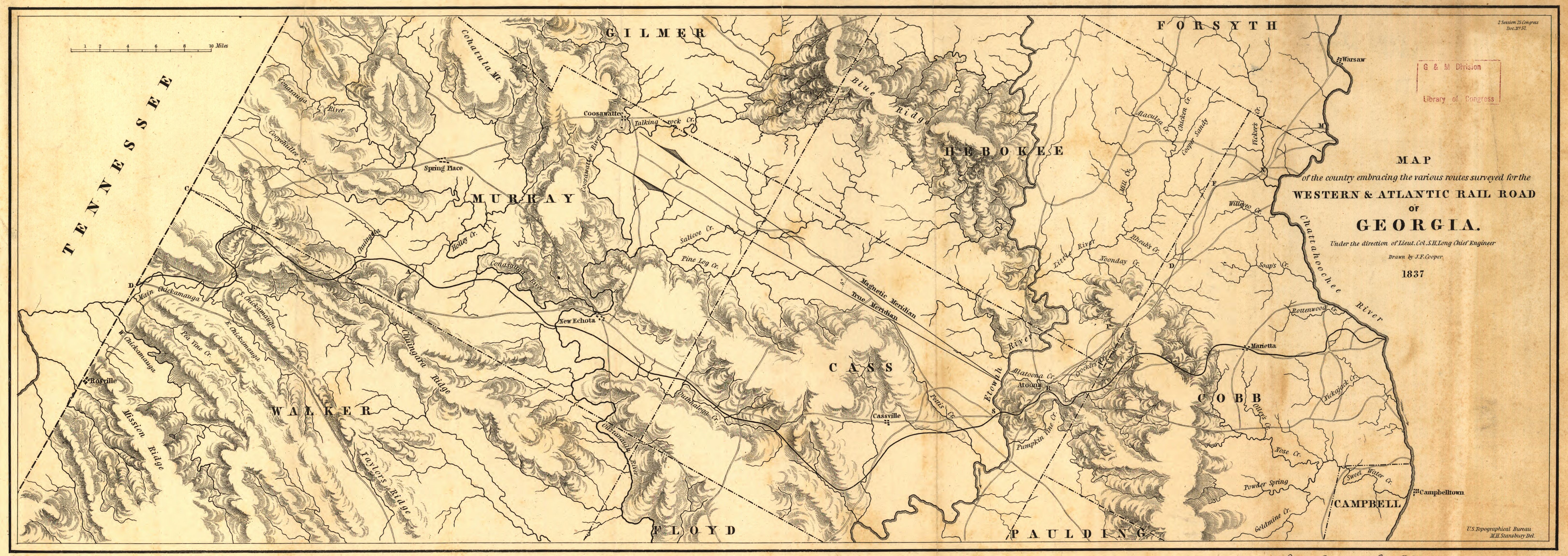
English: Includes area from Chattahoochee River between Warsaw and Cambelltown, and west to the Tennessee boundary. Shows cities, townships, roads, drainage, and relief by hachures. The 138-mile route was opened in 1850. |
||
| Title | Map of the country embracing the various routes surveyed for the Western & Atlantic Rail Road of Georgia, under the direction of Lieut. Col. S. H. Long, Chief Engineer, 1837, U.S. Topographical Bureau M. H. Stansbury, Del. | ||
| Shelf ID | G3921.P3 1837 .C6 | ||
| Date | |||
| Source | https://www.loc.gov/item/98688853/ | ||
| Author | Cooper, J. F.; Western And Atlantic Railroad Company; Arms, F. C. | ||
| Permission (Reusing this file) |
|
||
| Other versions |
|
||
| Location | United States · Georgia | ||
| Part of | American Memory · Catalog · Railroad Maps, 1828-1900 · Geography And Map Division · Transportation And Communication | ||
| Subject | United States · Maps · Western And Atlantic Railroad Company · Railroads · Georgia |

Licensing
edit
|
This is a faithful photographic reproduction of a two-dimensional, public domain work of art. The work of art itself is in the public domain for the following reason:
The official position taken by the Wikimedia Foundation is that "faithful reproductions of two-dimensional public domain works of art are public domain".
This photographic reproduction is therefore also considered to be in the public domain in the United States. In other jurisdictions, re-use of this content may be restricted; see Reuse of PD-Art photographs for details. | ||||
File history
Click on a date/time to view the file as it appeared at that time.
| Date/Time | Thumbnail | Dimensions | User | Comment | |
|---|---|---|---|---|---|
| current | 12:43, 17 May 2018 | 6,493 × 2,304 (2.89 MB) | Fæ (talk | contribs) | LOC Maps https://www.loc.gov/item/98688853/ #1203 |
You cannot overwrite this file.
File usage on Commons
The following page uses this file: