File:Map of the middle states of North America with part of Canada shewing the situation of the principal towns, viz. Columbia (i.e. Washington, D.C.), Baltimore, Philadelphia, New York, Newport, Rhode LOC 2010589243.tif

Size of this JPG preview of this TIF file: 478 × 600 pixels. Other resolutions: 191 × 240 pixels | 382 × 480 pixels | 612 × 768 pixels | 816 × 1,024 pixels | 1,632 × 2,048 pixels | 5,052 × 6,339 pixels.
Original file (5,052 × 6,339 pixels, file size: 91.62 MB, MIME type: image/tiff)
Captions
Captions
Add a one-line explanation of what this file represents
Summary edit
| Description |
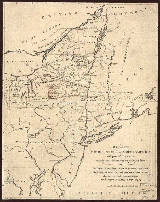
English: Item 32 in exhibit, "City of magnificent distances, the nation's capital," that was presented in 1991 at Library of Congress. Map incorrectly locates "Columbia" (Washington, D.C.) on Shenandoah River Available also through the Library of Congress Web site as a raster image. Copy imperfect: Soiled, annotated in pen-and-ink. |
||
| Title | Map of the middle states of North America with part of Canada shewing the situation of the principal towns, viz. Columbia [i.e. Washington, D.C.], Baltimore, Philadelphia, New York, Newport, Rhode Island, Boston & Montreal, also their several communications with respect to Lake Ontario. | ||
| Shelf ID | G3715 1791 .M3 | ||
| Date | |||
| Source | https://www.loc.gov/item/2010589243/ | ||
| Author | Unknown author | ||
| Permission (Reusing this file) |
|
||
| Other versions |
|
||
| Location | Canada · New England · Middle Atlantic States · Canada, Eastern · Eastern | ||
| Part of | American Memory · General Maps · Catalog · Geography And Map Division | ||
| Subject | Maps · Early Works To 1800 · Middle Atlantic States · New England · Canada, Eastern |

,_Baltimore,_Philadelphia,_New_York,_Newport,_Rhode_LOC_2010589243.jpg)
Licensing edit
|
This is a faithful photographic reproduction of a two-dimensional, public domain work of art. The work of art itself is in the public domain for the following reason:
The official position taken by the Wikimedia Foundation is that "faithful reproductions of two-dimensional public domain works of art are public domain".
This photographic reproduction is therefore also considered to be in the public domain in the United States. In other jurisdictions, re-use of this content may be restricted; see Reuse of PD-Art photographs for details. | ||||
File history
Click on a date/time to view the file as it appeared at that time.
| Date/Time | Thumbnail | Dimensions | User | Comment | |
|---|---|---|---|---|---|
| current | 22:23, 17 May 2018 |  | 5,052 × 6,339 (91.62 MB) | Fæ (talk | contribs) | LOC Maps https://www.loc.gov/item/2010589243/ #10427 |
You cannot overwrite this file.
File usage on Commons
The following page uses this file: