File:Map of the towns of Somers & Yorktown, Westchester Co. New York. LOC 2008620058.tif

Size of this JPG preview of this TIF file: 768 × 600 pixels. Other resolutions: 308 × 240 pixels | 615 × 480 pixels | 984 × 768 pixels | 1,280 × 999 pixels | 2,560 × 1,998 pixels | 14,665 × 11,448 pixels.
Original file (14,665 × 11,448 pixels, file size: 480.32 MB, MIME type: image/tiff)
Captions
Captions
Add a one-line explanation of what this file represents
Summary
edit| Warning | The original file is very high-resolution. It might not load properly or could cause your browser to freeze when opened at full size. |
|---|
| Description |
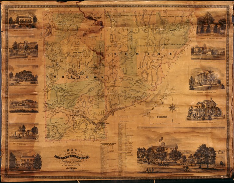
English: Wall map with wooden rods at top and bottom. Relief shown by hachures. Also shows rural buildings, householders' names, school districts, and election districts. Hand col. to show election districts. Available also through the Library of Congress Web site as a raster image. LC copy imperfect: Darkened, water-stained, brittle, cracked, missing margin sections. Includes notes, inset of Somers village, business directories of map subscribers' names, and ill. of prominent buildings/residences. Acquisitions control no.: 2008-084 |
||
| Title | Map of the towns of Somers & Yorktown, Westchester Co. New York. | ||
| Shelf ID | G3804.S72 1862 .C5 | ||
| Date | |||
| Source | https://www.loc.gov/item/2008620058/ | ||
| Author | Clark & Wagner | ||
| Permission (Reusing this file) |
|
||
| Other versions |
|
||
| Location | Town · Somers (Town) · Somers · Yorktown · United States · New York · Yorktown (Town) | ||
| Part of | American Memory · Cities And Towns · Catalog · Geography And Map Division | ||
| Subject | Somers (N.Y.) · Somers (Town) · Somers · New York · Election Districts · Yorktown (Town) · United States · Maps · Somers (N.Y. : Town) · School Districts · Yorktown (N.Y. : Town) · New York (State) · Landowners |


Licensing
edit|
This is a faithful photographic reproduction of a two-dimensional, public domain work of art. The work of art itself is in the public domain for the following reason:
The official position taken by the Wikimedia Foundation is that "faithful reproductions of two-dimensional public domain works of art are public domain".
This photographic reproduction is therefore also considered to be in the public domain in the United States. In other jurisdictions, re-use of this content may be restricted; see Reuse of PD-Art photographs for details. | ||||
File history
Click on a date/time to view the file as it appeared at that time.
| Date/Time | Thumbnail | Dimensions | User | Comment | |
|---|---|---|---|---|---|
| current | 11:48, 5 June 2018 |  | 14,665 × 11,448 (480.32 MB) | Fæ (talk | contribs) | LOC Maps https://www.loc.gov/item/2008620058/ #5668 |
You cannot overwrite this file.
File usage on Commons
The following page uses this file: