File:Map of village lots and cottage sites at Dearman, Westchester Co. - adjacent to the Hudson River station & Piermont Ferry depot - to be sold at auction by Cole & Chilton on Thursday 25th April 1850 at LOC 2013589278.tif

Size of this JPG preview of this TIF file: 800 × 414 pixels. Other resolutions: 320 × 166 pixels | 640 × 332 pixels | 1,024 × 530 pixels | 1,280 × 663 pixels | 2,560 × 1,326 pixels | 9,584 × 4,965 pixels.
Original file (9,584 × 4,965 pixels, file size: 136.14 MB, MIME type: image/tiff)
Captions
Captions
Add a one-line explanation of what this file represents
Summary edit
| Description |
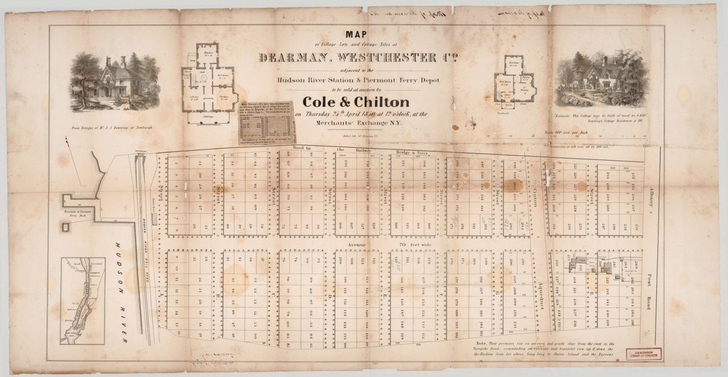
English: Cadastral map showing residential lots, lot numbers, existing buildings, and planned placement of street-side trees in a new subdivision now part of the incorporated village of Irvington (N.Y.). The name Dearman was changed to Irvington in 1857 to honor Washington Irving. LC copy imperfect: Extensively fold-lined, missing small sections at fold lines, slight stains, newspaper clipping with lot prices affixed to recto, annotated in ink handwriting on verso. Includes note, location map (inset), 2 cottage floorplans, and 2 vignettes of planned cottages. Available also through the Library of Congress Web site as a raster image. |
||
| Title | Map of village lots and cottage sites at Dearman, Westchester Co. : adjacent to the Hudson River station & Piermont Ferry depot : to be sold at auction by Cole & Chilton on Thursday 25th April 1850 at 12 o'clock at the Merchants' Exchange N.Y. | ||
| Shelf ID | G3804.I5G46 1850 .C6 | ||
| Date | |||
| Source | https://www.loc.gov/item/2013589278/ | ||
| Author | Cole & Chilton; Miller & Co. | ||
| Permission (Reusing this file) |
|
||
| Other versions |
|
||
| Location | United States · New York · New York (State) · Irvington | ||
| Part of | American Memory · Cities And Towns · Catalog · Geography And Map Division | ||
| Subject | Cadastral Maps · Housing Development · United States · Maps · Irvington · Irvington (N.Y.) · Real Property · New York (State) |


Licensing edit
|
This is a faithful photographic reproduction of a two-dimensional, public domain work of art. The work of art itself is in the public domain for the following reason:
The official position taken by the Wikimedia Foundation is that "faithful reproductions of two-dimensional public domain works of art are public domain".
This photographic reproduction is therefore also considered to be in the public domain in the United States. In other jurisdictions, re-use of this content may be restricted; see Reuse of PD-Art photographs for details. | ||||
File history
Click on a date/time to view the file as it appeared at that time.
| Date/Time | Thumbnail | Dimensions | User | Comment | |
|---|---|---|---|---|---|
| current | 01:06, 23 May 2018 |  | 9,584 × 4,965 (136.14 MB) | Fæ (talk | contribs) | LOC Maps https://www.loc.gov/item/2013589278/ #13518 |
You cannot overwrite this file.
File usage on Commons
The following page uses this file: