File:Map of warranty-deed land tracts in the western part of Wyoming County, Pa. LOC 2012590198.tif

Size of this JPG preview of this TIF file: 748 × 600 pixels. Other resolutions: 299 × 240 pixels | 599 × 480 pixels | 958 × 768 pixels | 1,277 × 1,024 pixels | 2,555 × 2,048 pixels | 8,530 × 6,839 pixels.
Original file (8,530 × 6,839 pixels, file size: 166.9 MB, MIME type: image/tiff)
Captions
Captions
Add a one-line explanation of what this file represents
Summary edit
| Description |
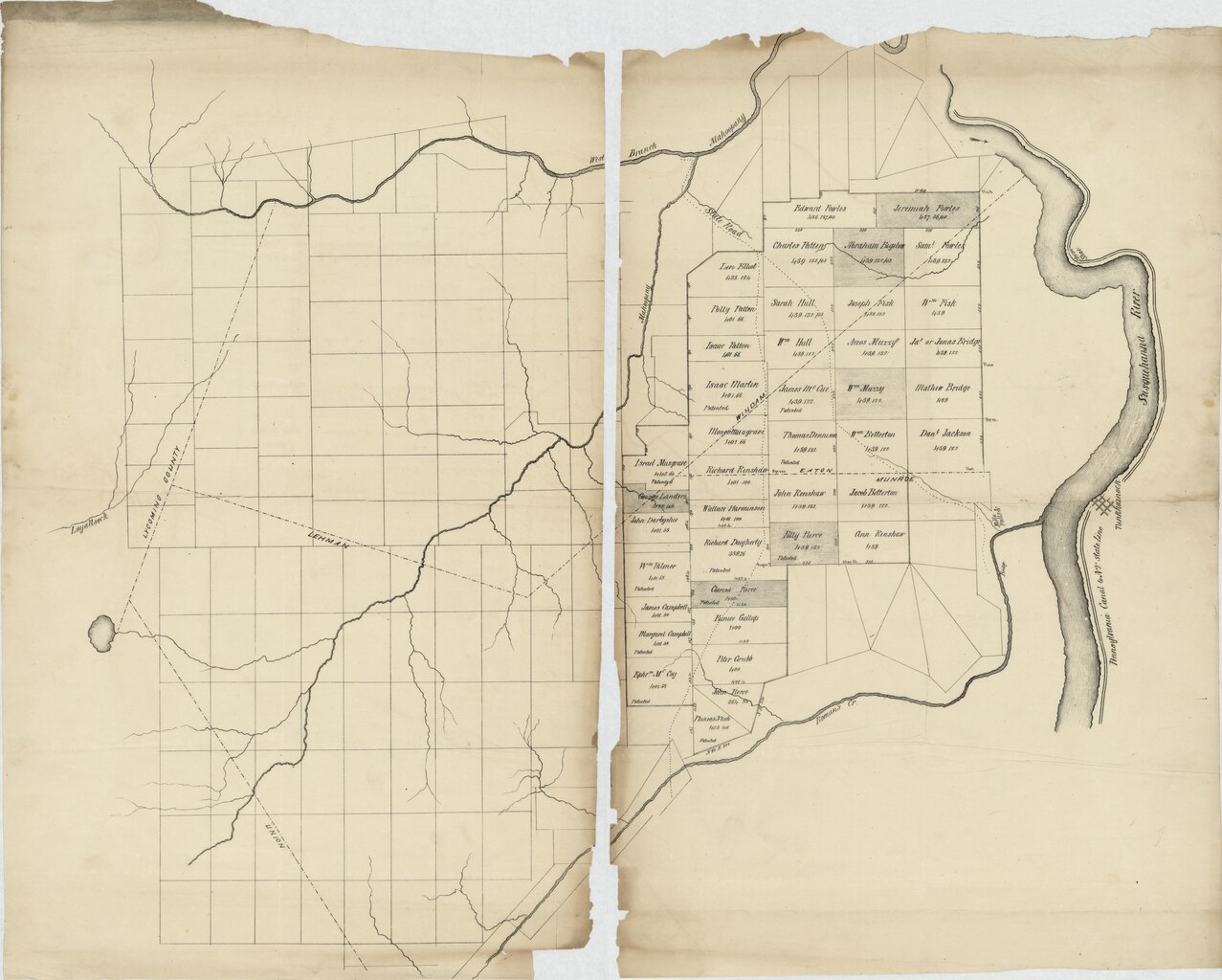
English: Shows warranty-deed tract lines, acreages, warrantees' names, and line dimensions in Windham, Eaton, Monroe, and Lehman townships of Wyoming County, Pa. Some named tracts are designated as "Patented". Some tracts are not named or numbered. The Susquehanna River and Tunkhannock borough are shown at the eastern end of the map. There is no attribution present. Title devised by cataloguer. The map appears to have been printed originally on a single sheet (later halved). LC copy imperfect: Brittle, halved, fold-lined, missing small sections along central (vertical) cut line, missing larger sections along upper sheet edges (including cartographic content). Available also through the Library of Congress Web site as a raster image. |
||
| Title | [Map of warranty-deed land tracts in the western part of Wyoming County, Pa.] | ||
| Shelf ID | G3823.W9G46 185- .M3 | ||
| Date | |||
| Source | //lccn.loc.gov/2012590198 | ||
| Author | Unknown author | ||
| Permission (Reusing this file) |
|
||
| Other versions |
|
||
| Location | United States · Pennsylvania · Pennsylvania · Wyoming County · Wyoming County | ||
| Part of | Catalog · Geography And Map Division | ||
| Subject | Cadastral Maps · Wyoming County · Pennsylvania · Warranty Of Title · United States · Maps · Real Property · Landowners |


Licensing edit
|
This is a faithful photographic reproduction of a two-dimensional, public domain work of art. The work of art itself is in the public domain for the following reason:
The official position taken by the Wikimedia Foundation is that "faithful reproductions of two-dimensional public domain works of art are public domain".
This photographic reproduction is therefore also considered to be in the public domain in the United States. In other jurisdictions, re-use of this content may be restricted; see Reuse of PD-Art photographs for details. | ||||
File history
Click on a date/time to view the file as it appeared at that time.
| Date/Time | Thumbnail | Dimensions | User | Comment | |
|---|---|---|---|---|---|
| current | 02:05, 23 May 2018 |  | 8,530 × 6,839 (166.9 MB) | Fæ (talk | contribs) | LOC Maps //lccn.loc.gov/2012590198 #13539 |
You cannot overwrite this file.
File usage on Commons
The following 3 pages use this file: