File:Map prepared to exhibit the campaigns in which the Army of the Cumberland took part during the War of the Rebellion. (1861-65) LOC 99447204.tif

Size of this JPG preview of this TIF file: 726 × 599 pixels. Other resolutions: 291 × 240 pixels | 582 × 480 pixels | 930 × 768 pixels | 1,240 × 1,024 pixels | 2,481 × 2,048 pixels | 10,228 × 8,444 pixels.
Original file (10,228 × 8,444 pixels, file size: 247.09 MB, MIME type: image/tiff)
Captions
Captions
Add a one-line explanation of what this file represents
Summary
edit| Warning | The original file is very high-resolution. It might not load properly or could cause your browser to freeze when opened at full size. |
|---|
| Description |
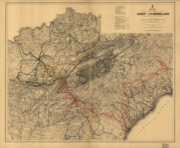
English: Scale 1:1,267,200. LC Civil War Maps (2nd ed.), 84 Map of South Carolina, Kentucky, and Tennessee, and parts of Georgia, Alabama, Mississippi, North Carolina, and Virginia, showing roads, railroads, towns, rivers, names and boundaries of states, and relief by hachures. Lines of march are indicated by colors and symbols. Includes "Jeff. Davis' line of flight." Another copy is in the Sherman Map Coll. No.5. Description derived from published bibliography. Available also through the Library of Congress web site as raster image. |
||
| Title | Map prepared to exhibit the campaigns in which the Army of the Cumberland took part during the War of the Rebellion. [1861-65] | ||
| Shelf ID | G3866.S5 1865 .R9 | ||
| Date | |||
| Source | https://www.loc.gov/item/99447204/ | ||
| Author | Ruger, Edward | ||
| Permission (Reusing this file) |
|
||
| Other versions |
|
||
| Location | United States · Southern States | ||
| Part of | Military Battles And Campaigns · American Memory · Civil War Maps · Catalog · Geography And Map Division | ||
| Subject | United States · Civil War · Campaigns · Maps · Southern States · History |

_LOC_99447204.jpg)
Licensing
edit|
This is a faithful photographic reproduction of a two-dimensional, public domain work of art. The work of art itself is in the public domain for the following reason:
The official position taken by the Wikimedia Foundation is that "faithful reproductions of two-dimensional public domain works of art are public domain".
This photographic reproduction is therefore also considered to be in the public domain in the United States. In other jurisdictions, re-use of this content may be restricted; see Reuse of PD-Art photographs for details. | ||||
File history
Click on a date/time to view the file as it appeared at that time.
| Date/Time | Thumbnail | Dimensions | User | Comment | |
|---|---|---|---|---|---|
| current | 04:22, 24 June 2018 |  | 10,228 × 8,444 (247.09 MB) | Fæ (talk | contribs) | LOC Maps https://www.loc.gov/item/99447204/ #26132 |
You cannot overwrite this file.
File usage on Commons
The following page uses this file: