File:Maryland und Delaware. LOC 76695379.tif

Size of this JPG preview of this TIF file: 800 × 556 pixels. Other resolutions: 320 × 222 pixels | 640 × 445 pixels | 1,024 × 711 pixels | 1,280 × 889 pixels | 2,560 × 1,778 pixels | 7,951 × 5,523 pixels.
Original file (7,951 × 5,523 pixels, file size: 125.64 MB, MIME type: image/tiff)
Captions
Captions
Add a one-line explanation of what this file represents
Summary edit
| Description |
English: Scale ca. 1:500,000. Relief shown by hachures. Place names in English and German. In upper right margin: No. X. Includes inset of western section of what is now Garrett and Allegany Counties. Available also through the Library of Congress Web site as a raster image. Vault AACR2: 100; 651/1; 651/2 |
||
| Title | Maryland und Delaware. | ||
| Shelf ID | G3840 1797 .S6 | ||
| Date | |||
| Source | https://www.loc.gov/item/76695379/ | ||
| Author | Sotzmann, D. F.; Sander, Wilhelm | ||
| Permission (Reusing this file) |
|
||
| Other versions |
|
||
| Location | United States · Maryland · Delaware | ||
| Part of | American Memory · General Maps · Catalog · Geography And Map Division | ||
| Subject | United States · Maps · Maryland · Delaware · Early Works To 1800 |


Licensing edit
|
This is a faithful photographic reproduction of a two-dimensional, public domain work of art. The work of art itself is in the public domain for the following reason:
The official position taken by the Wikimedia Foundation is that "faithful reproductions of two-dimensional public domain works of art are public domain".
This photographic reproduction is therefore also considered to be in the public domain in the United States. In other jurisdictions, re-use of this content may be restricted; see Reuse of PD-Art photographs for details. | ||||
File history
Click on a date/time to view the file as it appeared at that time.
| Date/Time | Thumbnail | Dimensions | User | Comment | |
|---|---|---|---|---|---|
| current | 02:31, 21 May 2018 | 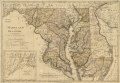 | 7,951 × 5,523 (125.64 MB) | Fæ (talk | contribs) | LOC Maps https://www.loc.gov/item/76695379/ #532 |
You cannot overwrite this file.
File usage on Commons
The following page uses this file: