File:Mettingen Heimathaus 06.jpg
Size of this preview: 800 × 414 pixels. Other resolutions: 320 × 166 pixels | 640 × 332 pixels | 1,024 × 531 pixels | 1,280 × 663 pixels | 2,560 × 1,326 pixels | 5,312 × 2,752 pixels.
Original file (5,312 × 2,752 pixels, file size: 11.03 MB, MIME type: image/jpeg)
Captions
Captions
Add a one-line explanation of what this file represents
Summary
edit| Description |
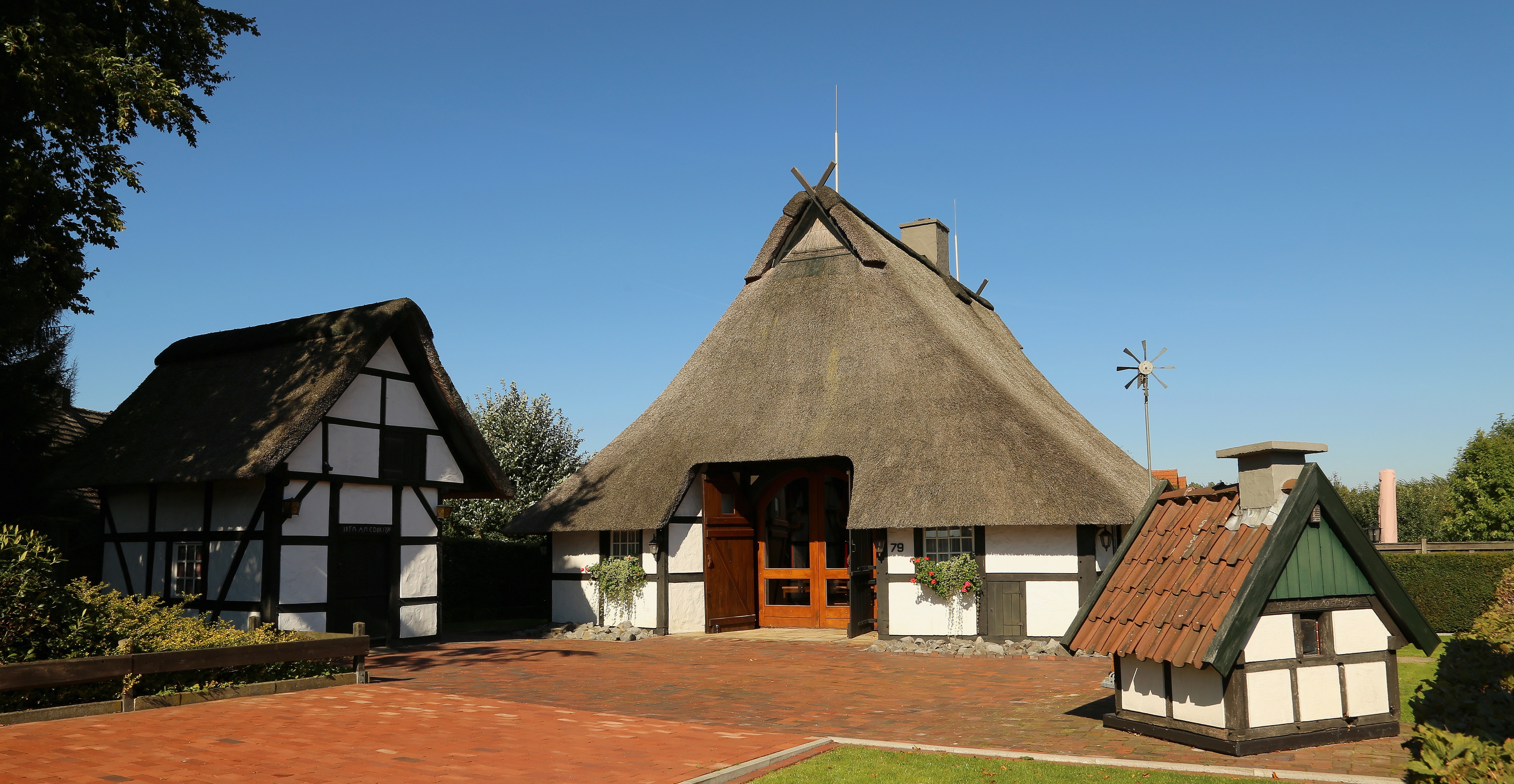
English: Heimathaus, a small former farmhouse, in Mettingen-Wiehe, Kreis Steinfurt, North Rhine-Westphalia, Germany.
Deutsch: Heimathaus am Wieher Eschweg in Mettingen-Wiehe, Kreis Steinfurt, Nordrhein-Westfalen, Deutschland. Das heute vom Heimatverein Mettingen als Heimathaus genutzte Fachwerkhaus wurde in Zweiständerbauweise mit Reetdach errichtet. An der Nordseite ist das Walmdach weit ausragend ausgebildet. Als Baujahr wird 1541 angegeben. Das Heimathaus ist das ehemalige Heuerhaus des benachbarten Brenninckhofes. Von 1972 bis 1975 wurde es von dort umgesetzt und renoviert. Das kleinere Gebäude links ist ein Backhaus aus dem Jahr 1796, das ursprünglich vom Gut Langenbrück (Westerkappeln) stammt. Im Herbst 2009 wurde das Reetdach des Heuerhauses umfassend erneuert.
|
||||||||||||||||||||||||||
| Date | |||||||||||||||||||||||||||
| Source | Own work | ||||||||||||||||||||||||||
| Author |
|
||||||||||||||||||||||||||

| Camera location | | View this and other nearby images on: OpenStreetMap |
|---|

|
This image was uploaded as part of Wiki Loves Monuments 2013.
|
Licensing
edit
I, the copyright holder of this work, hereby publish it under the following licenses:

|
Permission is granted to copy, distribute and/or modify this document under the terms of the GNU Free Documentation License, Version 1.2 or any later version published by the Free Software Foundation; with no Invariant Sections, no Front-Cover Texts, and no Back-Cover Texts. A copy of the license is included in the section entitled GNU Free Documentation License. |
This file is licensed under the Creative Commons Attribution-Share Alike 3.0 Unported, 2.5 Generic, 2.0 Generic and 1.0 Generic license.
- You are free:
- to share – to copy, distribute and transmit the work
- to remix – to adapt the work
- Under the following conditions:
- attribution – You must give appropriate credit, provide a link to the license, and indicate if changes were made. You may do so in any reasonable manner, but not in any way that suggests the licensor endorses you or your use.
- share alike – If you remix, transform, or build upon the material, you must distribute your contributions under the same or compatible license as the original.
You may select the license of your choice.
File history
Click on a date/time to view the file as it appeared at that time.
| Date/Time | Thumbnail | Dimensions | User | Comment | |
|---|---|---|---|---|---|
| current | 12:44, 29 September 2013 | | 5,312 × 2,752 (11.03 MB) | J.-H. Janßen (talk | contribs) | {{Information |Description={{en|1=Heimathaus, a small former farmhouse, in Mettingen-Wiehe, Kreis Steinfurt, North Rhine-Westphalia, Germany.}} {{de|1=Heimathaus am Wieher Eschweg in Mettingen-Wiehe, Kreis Steinfurt, [[Nordrhein... |
You cannot overwrite this file.
File usage on Commons
The following 3 pages use this file:
File usage on other wikis
The following other wikis use this file:
- Usage on de.wikipedia.org
- Usage on www.wikidata.org