File:Microblade (dorsal) (FindID 837087).jpg
Size of this preview: 450 × 600 pixels. Other resolutions: 180 × 240 pixels | 360 × 480 pixels | 576 × 768 pixels | 1,200 × 1,600 pixels.
Original file (1,200 × 1,600 pixels, file size: 712 KB, MIME type: image/jpeg)
Captions
Captions
Add a one-line explanation of what this file represents
Summary
edit_(FindID_837087).jpg&action=edit§ion=1)
| microblade (dorsal) | |||
|---|---|---|---|
| Photographer |
Royal Institution of Cornwall, Anna Tyacke, 2017-03-16 16:44:35 |
||
| Title |
microblade (dorsal) |
||
| Description |
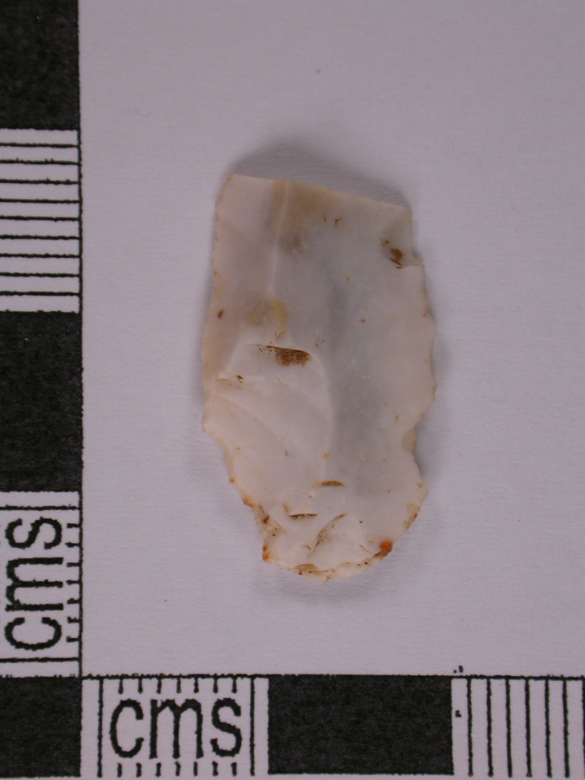
English: A snapped flint microblade, sub-rectangular in plan, plano-convex in profile and triangular in section. The proximal end of a Mesolithic microblade representing approximately half of the original. The point and bulb of percussion are clearly visible at the proximal end of the ventral face. The scars of removal of three earlier microflakes are visible on the dorsal face. The left margin of the dorsal face has been retouched to create a cutting edge and the right margin appears notched but this is likely due to damage. Microblades and microflakes occur in large numbers in many Mesolithic assmblages. The surface of the flint is completely patinated white in colour, mottled with pale grey and derives from a local beach pebble.
Bond (2004) illustrates several similar Mesolithic flakes and blades on pages 108 & 112, figs.5.92 & 5.96, nos.149-152 & 19-20. |
||
| Depicted place | (County of findspot) Cornwall | ||
| Date | between 8300 BC and 4500 BC | ||
| Accession number |
FindID: 837087 Old ref: CORN-ABABCB Filename: DSCN4683.JPG |
||
| Credit line |
|
||
| Source |
https://finds.org.uk/database/ajax/download/id/607142 Catalog: https://finds.org.uk/database/images/image/id/607142/recordtype/artefacts archive copy at the Wayback Machine Artefact: https://finds.org.uk/database/artefacts/record/id/837087 |
||
| Permission (Reusing this file) |
Attribution License version 2.0 (verified 24 November 2020) | ||
| Object location | | View this and other nearby images on: OpenStreetMap |
|---|
_(FindID_837087).jpg¶ms=050.562600_N_-004.873740_E_globe:Earth_class:object_type:object__&language=en)
Licensing
edit_(FindID_837087).jpg&action=edit§ion=2)
This file is licensed under the Creative Commons Attribution 2.0 Generic license.
Attribution: Royal Institution of Cornwall
- You are free:
- to share – to copy, distribute and transmit the work
- to remix – to adapt the work
- Under the following conditions:
- attribution – You must give appropriate credit, provide a link to the license, and indicate if changes were made. You may do so in any reasonable manner, but not in any way that suggests the licensor endorses you or your use.
File history
Click on a date/time to view the file as it appeared at that time.
| Date/Time | Thumbnail | Dimensions | User | Comment | |
|---|---|---|---|---|---|
| current | 10:34, 17 December 2018 | | 1,200 × 1,600 (712 KB) | Fæ (talk | contribs) | Portable Antiquities Scheme, CORN, FindID: 837087, mesolithic, page 2068, batch count 15433 |
You cannot overwrite this file.
File usage on Commons
The following page uses this file:
_(FindID_837087).jpg)
_(FindID_837087).jpg&oldid=846047955)