File:Military power of NATO and the Warsaw Pact states in 1973.svg

Size of this PNG preview of this SVG file: 450 × 456 pixels. Other resolutions: 237 × 240 pixels | 474 × 480 pixels | 758 × 768 pixels | 1,011 × 1,024 pixels | 2,021 × 2,048 pixels.
Original file (SVG file, nominally 450 × 456 pixels, file size: 613 KB)
Captions
Captions
Add a one-line explanation of what this file represents
Summary edit
| Description |
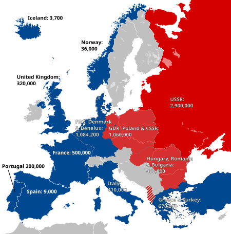
English: Map of Europe showing NATO (blue) and the Warsaw Pact (red), as well as the size of the military in various member states ca. 1973. |
| Date | (UTC) |
| Source |
This file was derived from: NATO and the Warsaw Pact 1973.svg:  |
| Author |
derivative work: Alphathon /'æɫfə.θɒn/ (talk)
|
| Other versions |
Licensing edit
I, the copyright holder of this work, hereby publish it under the following license:
This file is licensed under the Creative Commons Attribution-Share Alike 3.0 Unported license.
- You are free:
- to share – to copy, distribute and transmit the work
- to remix – to adapt the work
- Under the following conditions:
- attribution – You must give appropriate credit, provide a link to the license, and indicate if changes were made. You may do so in any reasonable manner, but not in any way that suggests the licensor endorses you or your use.
- share alike – If you remix, transform, or build upon the material, you must distribute your contributions under the same or compatible license as the original.
Original upload log edit
This image is a derivative work of the following images:
- File:NATO_and_the_Warsaw_Pact_1973.svg licensed with Cc-by-sa-3.0
- 2012-02-25T18:32:03Z Alphathon 450x456 (488452 Bytes) == {{int:filedesc}} == {{Information |Description={{en|Map of Europe showing [[:en:NATO|NATO]] and the [[:en:Warsaw Pact|Warsaw Pact]] circa 1973.}} |Source={{Derived from|Blank_map_of_Europe_1956-1990.svg|display=50}} |Date=
Uploaded with derivativeFX
File history
Click on a date/time to view the file as it appeared at that time.
| Date/Time | Thumbnail | Dimensions | User | Comment | |
|---|---|---|---|---|---|
| current | 00:53, 23 July 2022 | | 450 × 456 (613 KB) | Kwamikagami (talk | contribs) | change to NATO blue; Liecht. not a member |
| 23:33, 25 February 2012 |  | 450 × 456 (613 KB) | Alphathon (talk | contribs) | Another error | |
| 23:32, 25 February 2012 |  | 450 × 456 (613 KB) | Alphathon (talk | contribs) | Fix error | |
| 23:30, 25 February 2012 |  | 450 × 456 (591 KB) | Alphathon (talk | contribs) | == {{int:filedesc}} == {{Information |Description={{en|Map of Europe showing NATO (blue) and the Warsaw Pact (red), as well as the size of the military in various member states ca. 1973.}}{{de|Karte von Europa mit [[:de... |
You cannot overwrite this file.
File usage on Commons
The following page uses this file:
File usage on other wikis
The following other wikis use this file:
- Usage on af.wikipedia.org
- Usage on ba.wikipedia.org
- Usage on da.wikipedia.org
- Usage on hy.wikipedia.org
- Usage on it.wikipedia.org
- Usage on nl.wikipedia.org
- Usage on ru.wikipedia.org
- Usage on uz.wikipedia.org