File:Moscow. LOC 79693328.jpg

Size of this preview: 707 × 600 pixels. Other resolutions: 283 × 240 pixels | 566 × 480 pixels | 905 × 768 pixels | 1,207 × 1,024 pixels | 2,414 × 2,048 pixels | 12,830 × 10,885 pixels.
Original file (12,830 × 10,885 pixels, file size: 16.63 MB, MIME type: image/jpeg)
Captions
Captions
Add a one-line explanation of what this file represents
Summary
edit| Warning | The original file is very high-resolution. It might not load properly or could cause your browser to freeze when opened at full size. |
|---|
| Description |
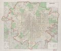
English: Scale 1:35,000. Shows wards. "Base: Plan g. Moskvy (Plan of the City of Moscow) 1:20,000, Second Edition, GUGK, Moscow, 1940." "12765." Includes glossary. Accompanied by index: Guide to streets and locations in Moscow. (72 p. : fold. col. map ; 22 cm.) Available also through the Library of Congress Web site as a raster image. AACR2 Comment: The map is an anachronistic assortment of the underlying 1940 map with the addition of some (but not all) areas developed after world war II like the new Moscow University campus on Sparrow Hills. Other areas developed prior to 1957 are shown in their 1940 or even earlier state (e.g. Komsomolsky Prospect and the beginning of Kutuzovsky Prospect, here nonexistent). Some areas were deliberately obfuscated (as in the Soviet sources), e.g. the Fili aircraft plant and airfield are shown as green forest |
||
| Title | Moscow. | ||
| Shelf ID | G7064.M7 1957 .U5 | ||
| Date | |||
| Source | https://www.loc.gov/item/79693328/ | ||
| Author | United States. Central Intelligence Agency | ||
| Permission (Reusing this file) |
|
||
| Other versions |
|
||
| Location | Moscow · Russia | ||
| Part of | American Memory · General Maps · Catalog · Geography And Map Division · Cities And Towns | ||
| Subject | Maps · Moscow · Moscow (Russia) · Russia |

Licensing
edit
| This image is a work of a Central Intelligence Agency employee, taken or made as part of that person's official duties. As a Work of the United States Government, this image or media is in the public domain in the United States.
|

|
| Annotations | This image is annotated: View the annotations at Commons |
File history
Click on a date/time to view the file as it appeared at that time.
| Date/Time | Thumbnail | Dimensions | User | Comment | |
|---|---|---|---|---|---|
| current | 12:31, 21 June 2018 | | 12,830 × 10,885 (16.63 MB) | Fæ (talk | contribs) | LOC Maps https://www.loc.gov/item/79693328/ #23091 |
You cannot overwrite this file.
File usage on Commons
The following page uses this file: