File:No. 1. County land from N.E. mile stone & John C. Rives' farm - (Washington D.C. and Prince Georges County, Md.) ; No. 2. Part of "Long Meadows" - (Washington D.C.). LOC 88690901.tif

Size of this JPG preview of this TIF file: 750 × 600 pixels. Other resolutions: 300 × 240 pixels | 600 × 480 pixels | 961 × 768 pixels | 1,280 × 1,024 pixels | 2,560 × 2,047 pixels | 6,323 × 5,056 pixels.
Original file (6,323 × 5,056 pixels, file size: 91.46 MB, MIME type: image/tiff)
Captions
Captions
Add a one-line explanation of what this file represents
Summary
edit| Description |
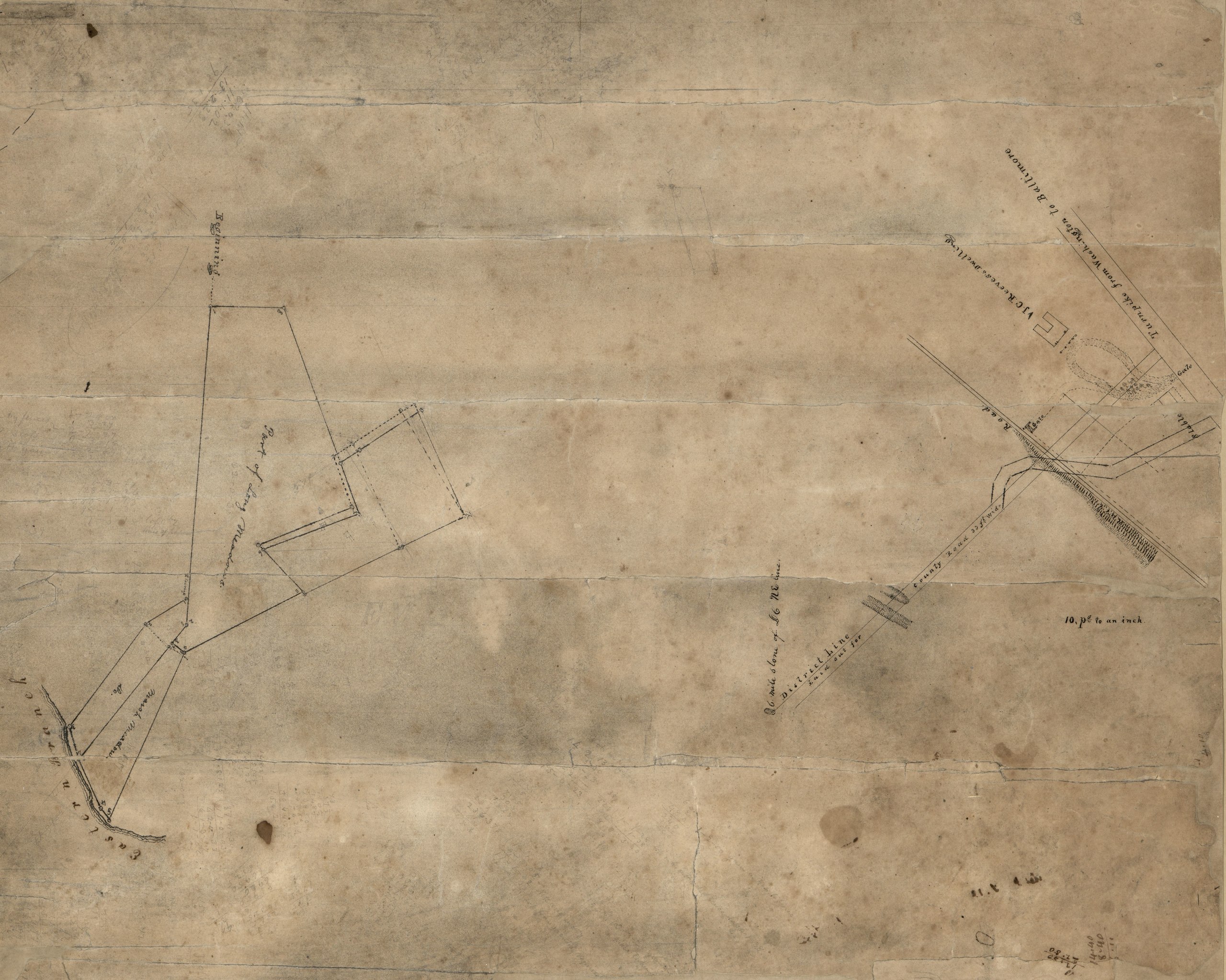
English: Cadastral survey maps. Relief shown by hachures. Orientation differs. Pen-and-ink and lead pencil. Fold-lined, torn, missing sections at fold lines and edges, and faced with rice paper. Includes computations. Titles in ink and lead pencil computations on verso. Available also through the Library of Congress Web site as a raster image. Vault DCP |
||
| Title | No. 1. County land from N.E. mile stone & John C. Rives' farm : [Washington D.C. and Prince Georges County, Md.] ; No. 2. Part of "Long Meadows" : [Washington D.C.]. | ||
| Shelf ID | G3851.G46 184- .N6 | ||
| Date | |||
| Source | https://www.loc.gov/item/88690901/ | ||
| Author | Unknown author | ||
| Permission (Reusing this file) |
|
||
| Other versions |
|
||
| Location | Prince George'S County · Washington D.C. · Washington · United States · Long Meadows (Washington) · District Of Columbia · Long Meadows · Maryland | ||
| Part of | American Memory · Catalog · County Landownership Maps · Geography And Map Division · Cultural Landscapes | ||
| Subject | Prince George'S County · Washington (D.C.) · Long Meadows (Washington, D.C.) · Estate · Maps, Manuscript · (John Cook) · Washington · United States · Maps · Long Meadows (Washington) · District Of Columbia · Rives, John C. · Real Property · Maryland · Manuscript Maps |

_;_No._2._Part_of_%22Long_Meadows%22_-_(Washington_D.C.)._LOC_88690901.jpg)
Licensing
edit|
This is a faithful photographic reproduction of a two-dimensional, public domain work of art. The work of art itself is in the public domain for the following reason:
The official position taken by the Wikimedia Foundation is that "faithful reproductions of two-dimensional public domain works of art are public domain".
This photographic reproduction is therefore also considered to be in the public domain in the United States. In other jurisdictions, re-use of this content may be restricted; see Reuse of PD-Art photographs for details. | ||||
File history
Click on a date/time to view the file as it appeared at that time.
| Date/Time | Thumbnail | Dimensions | User | Comment | |
|---|---|---|---|---|---|
| current | 04:46, 29 November 2018 |  | 6,323 × 5,056 (91.46 MB) | Fæ (talk | contribs) | LOC Maps https://www.loc.gov/item/88690901/ #4714 |
You cannot overwrite this file.
File usage on Commons
The following page uses this file: