File:Normal October-April precipitation, Arkansas-White-Red River basin - Colfax, Curry, Guadalupe, Harding, Mora, Quay, San Miguel, and Union counties, New Mexico. LOC 2003621389.jpg

Size of this preview: 800 × 533 pixels. Other resolutions: 320 × 213 pixels | 640 × 426 pixels | 1,024 × 682 pixels | 1,280 × 853 pixels | 2,560 × 1,705 pixels | 4,932 × 3,285 pixels.
Original file (4,932 × 3,285 pixels, file size: 1.55 MB, MIME type: image/jpeg)
Captions
Captions
Add a one-line explanation of what this file represents
Summary edit
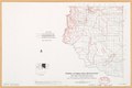
| Description |
English: "July 1978." "Base map prepared by SCS, Portland Carto Unit from USGS 1:1,000,000 national atlas. Thematic detail compiled by state staff from U.S. Department of Commerce, Environmental Science Services Administration, Weather Bureau, 1967." Includes location map. "M7-EN-22828-5." Available also through the Library of Congress Web site as a raster image. |
||
| Title | Normal October-April precipitation, Arkansas-White-Red River basin : Colfax, Curry, Guadalupe, Harding, Mora, Quay, San Miguel, and Union counties, New Mexico. | ||
| Shelf ID | G4052.A7C88 1978 .U55 | ||
| Date | |||
| Source | https://www.loc.gov/item/2003621389/ | ||
| Author | United States. Soil Conservation Service | ||
| Permission (Reusing this file) |
|
||
| Other versions |
|
||
| Location | Arkansas River Region · Red River Region · Arkansas River Region. · White River Region. · United States · White River Region · Arkansas · Red River Region. | ||
| Part of | American Memory · Catalog · Geography And Map Division · Additional Conservation And Environment Cartographic Items | ||
| Subject | Maps · Red River Region · Arkansas River Region · United States · White River Region · Arkansas · Precipitation (Meteorology) |

Licensing edit
| This work is from the Library of Congress. According to the library, there are no known copyright restrictions on the use of this work. |  |
File history
Click on a date/time to view the file as it appeared at that time.
| Date/Time | Thumbnail | Dimensions | User | Comment | |
|---|---|---|---|---|---|
| current | 01:20, 27 January 2020 | | 4,932 × 3,285 (1.55 MB) | Fæ (talk | contribs) | LOC Maps https://www.loc.gov/item/2003621389/ #12993 |
You cannot overwrite this file.
File usage on Commons
The following page uses this file: