File:North America - performed under the patronage of Louis Duke of Orleans, First Prince of the Blood by the Sieur d'Anville; greatly improved by Mr. Bolton; engrav,d by R. W. Seale; Gravelot, NYPL489836.tiff

Size of this JPG preview of this TIF file: 639 × 600 pixels. Other resolutions: 256 × 240 pixels | 511 × 480 pixels | 818 × 768 pixels | 1,091 × 1,024 pixels | 2,182 × 2,048 pixels | 5,474 × 5,139 pixels.
Original file (5,474 × 5,139 pixels, file size: 80.49 MB, MIME type: image/tiff)
Captions
Captions
Add a one-line explanation of what this file represents
Summary edit
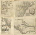
| Description | North America / performed under the patronage of Louis Duke of Orleans, First Prince of the Blood by the Sieur d'Anville ; greatly improved by Mr. Bolton ; engrav,d by R. W. Seale ; Gravelot, delin. ; Walker, sculp.; Lawrence H. Slaughter Collection of English maps, charts, globes, books and atlases / Charts and maps | ||||||||||||||||||||||||||||||||||||
| Notes | "Mr. Postlethwayt's Dictionary of commerce." ''Note 2.'') "N.B. This large map of North America was originally engrav'd at Paris, ..." ''Note 3.'') Also shows shoals, banks, and other navigational hazards off the coast of Nova Scotia and in the Caribbean area. ''Note 4.'') Copy in Map Div. 97-6155: Lawrence H. Slaughter Collection. ''Note 5.'') Includes historical and descriptive notes, and an inset chart of Baffin Bay and Hudson Bay. ''Note 6.'') Lawrence H. Slaughter Collection ; 550M. ''Note 7.'') National Endowment for the Humanities Grant for Access to Early Maps of the Middle Atlantic Seaboard. ''Note 8.'') Prime meridian: Ferro. ''Note 9.'') Relief shown pictorially. ''Note 10.'') Shows provinces, cities and towns, forts, Indian villages and tribal territory. | ||||||||||||||||||||||||||||||||||||
| Item physical description | 1 map : hand col. ; 82 x 83 cm. | ||||||||||||||||||||||||||||||||||||
| Catalogue call number | Map Div. 97-6155 [LHS 550M] | ||||||||||||||||||||||||||||||||||||
| Standard reference | LC Maps of North America, 1750-1789, 13 | ||||||||||||||||||||||||||||||||||||
| Date | |||||||||||||||||||||||||||||||||||||
| Source |
From The Lionel Pincus and Princess Firyal Map Division. http://maps.nypl.org http://digitalgallery.nypl.org/nypldigital/dgkeysearchdetail.cfm?imageID=489836
|
||||||||||||||||||||||||||||||||||||
| Author |
|
||||||||||||||||||||||||||||||||||||
| Other versions |
|
||||||||||||||||||||||||||||||||||||
| Location | Stephen A. Schwarzman Building / The Lionel Pincus and Princess Firyal Map Division | ||||||||||||||||||||||||||||||||||||
| Digital item published | 5-19-2004; updated 3-25-2011 | ||||||||||||||||||||||||||||||||||||
| Digital ID | 489836 | ||||||||||||||||||||||||||||||||||||


.jpg)

The making of this file was supported by Wikimedia UK.
To see other files made with the support of Wikimedia UK, please see the category Supported by Wikimedia UK.
|
Licensing edit
|
This is a faithful photographic reproduction of a two-dimensional, public domain work of art. The work of art itself is in the public domain for the following reason:
The official position taken by the Wikimedia Foundation is that "faithful reproductions of two-dimensional public domain works of art are public domain".
This photographic reproduction is therefore also considered to be in the public domain in the United States. In other jurisdictions, re-use of this content may be restricted; see Reuse of PD-Art photographs for details. | ||||
| This file is made available under the Creative Commons CC0 1.0 Universal Public Domain Dedication. | |
| The person who associated a work with this deed has dedicated the work to the public domain by waiving all of their rights to the work worldwide under copyright law, including all related and neighboring rights, to the extent allowed by law. You can copy, modify, distribute and perform the work, even for commercial purposes, all without asking permission.
|
File history
Click on a date/time to view the file as it appeared at that time.
| Date/Time | Thumbnail | Dimensions | User | Comment | |
|---|---|---|---|---|---|
| current | 10:21, 13 February 2022 |  | 5,474 × 5,139 (80.49 MB) | Sebastian Wallroth (talk | contribs) | Rotated 270° using CropTool with precise mode. |
| 16:42, 2 May 2014 |  | 5,248 × 5,475 (82.21 MB) | Fæ (talk | contribs) | GWToolset:: Creating mediafile for Fæ. Tranche 3 11591-16518 @ 2 May, 06:47 BST |
You cannot overwrite this file.
File usage on Commons
The following 5 pages use this file:
- File:North America, performed under the patronage of Louis Duke of Orleans, First Prince of the Blood; LOC 74694275.jpg
- File:North America. LOC 75693503.jpg
- File:North America. LOC 75693503.tif
- File:North America. Performed under the patronage of Louis, Duke of Orléans (d'Anville, Seale, etc.).jpg
- File:North America performed under the patronage of Louis Duke of Orleans, First Prince of the Blood by the Sieur d'Anville - greatly improved by Mr. Bolton; engrav,d by R. W. Seale; Gravelot, NYPL434597.tiff