File:Nunan's map of Ashland Co., Ohio - showing the sections, farms, lots, & villages LOC 2012592384.jpg

Size of this preview: 442 × 600 pixels. Other resolutions: 177 × 240 pixels | 354 × 480 pixels | 566 × 768 pixels | 754 × 1,024 pixels | 1,509 × 2,048 pixels | 12,585 × 17,080 pixels.
Original file (12,585 × 17,080 pixels, file size: 28.01 MB, MIME type: image/jpeg)
Captions
Captions
Add a one-line explanation of what this file represents
Summary
edit| Warning | The original file is very high-resolution. It might not load properly or could cause your browser to freeze when opened at full size. |
|---|
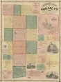
| Description |
English: LC Land ownership maps, 597 Available also through the Library of Congress Web site as a raster image. Includes distance table, views of public, and residential properties. Insets: Sullivan, Sullivan Tp -- Perrysburg, Jackson Twp. -- Plan of the town of Ashland, Montgomery Township -- Lafayette, Perry Twp. -- Polk, Jackson Tp -- Troy, Troy Twp. -- Mohecanville, Mohecan Twp. -- Rowsburg, Perry Twp. -- Savannah, Clearcreek Twp. -- Hayesville, Vermillion Twp. -- Mifflin, Mifflin Twp. -- Loudonville, Hanover Twp. -- Jeromeville, Tp -- Orange, Orange Twp. -- Perrysville, Green Twp. |
||
| Title | Nunan's map of Ashland Co., Ohio : showing the sections, farms, lots, & villages | ||
| Shelf ID | G4083.A6G46 1861 .N8 | ||
| Date | |||
| Source | https://www.loc.gov/item/2012592384/ | ||
| Author | Nunan, Philip; Plumb, H. S.; Schuchman, William | ||
| Permission (Reusing this file) |
|
||
| Other versions |
|
||
| Location | United States · Ashland County · Ohio | ||
| Part of | American Memory · Catalog · County Landownership Maps · Geography And Map Division · Cultural Landscapes | ||
| Subject | Ashland County · United States · Maps · Ohio · Real Property · Landowners |

Licensing
edit
|
This is a faithful photographic reproduction of a two-dimensional, public domain work of art. The work of art itself is in the public domain for the following reason:
The official position taken by the Wikimedia Foundation is that "faithful reproductions of two-dimensional public domain works of art are public domain".
This photographic reproduction is therefore also considered to be in the public domain in the United States. In other jurisdictions, re-use of this content may be restricted; see Reuse of PD-Art photographs for details. | ||||
File history
Click on a date/time to view the file as it appeared at that time.
| Date/Time | Thumbnail | Dimensions | User | Comment | |
|---|---|---|---|---|---|
| current | 07:34, 24 June 2018 | | 12,585 × 17,080 (28.01 MB) | Fæ (talk | contribs) | LOC Maps https://www.loc.gov/item/2012592384/ #26294 |
You cannot overwrite this file.
File usage on Commons
The following page uses this file: