File:Nuova California (NBY 15537).jpg
Size of this preview: 774 × 599 pixels. Other resolutions: 310 × 240 pixels | 620 × 480 pixels | 992 × 768 pixels | 1,280 × 991 pixels | 2,560 × 1,983 pixels | 3,600 × 2,788 pixels.
Original file (3,600 × 2,788 pixels, file size: 2.15 MB, MIME type: image/jpeg)
Captions
Captions
Add a one-line explanation of what this file represents
Summary
edit.jpg&action=edit§ion=1)
| Description |
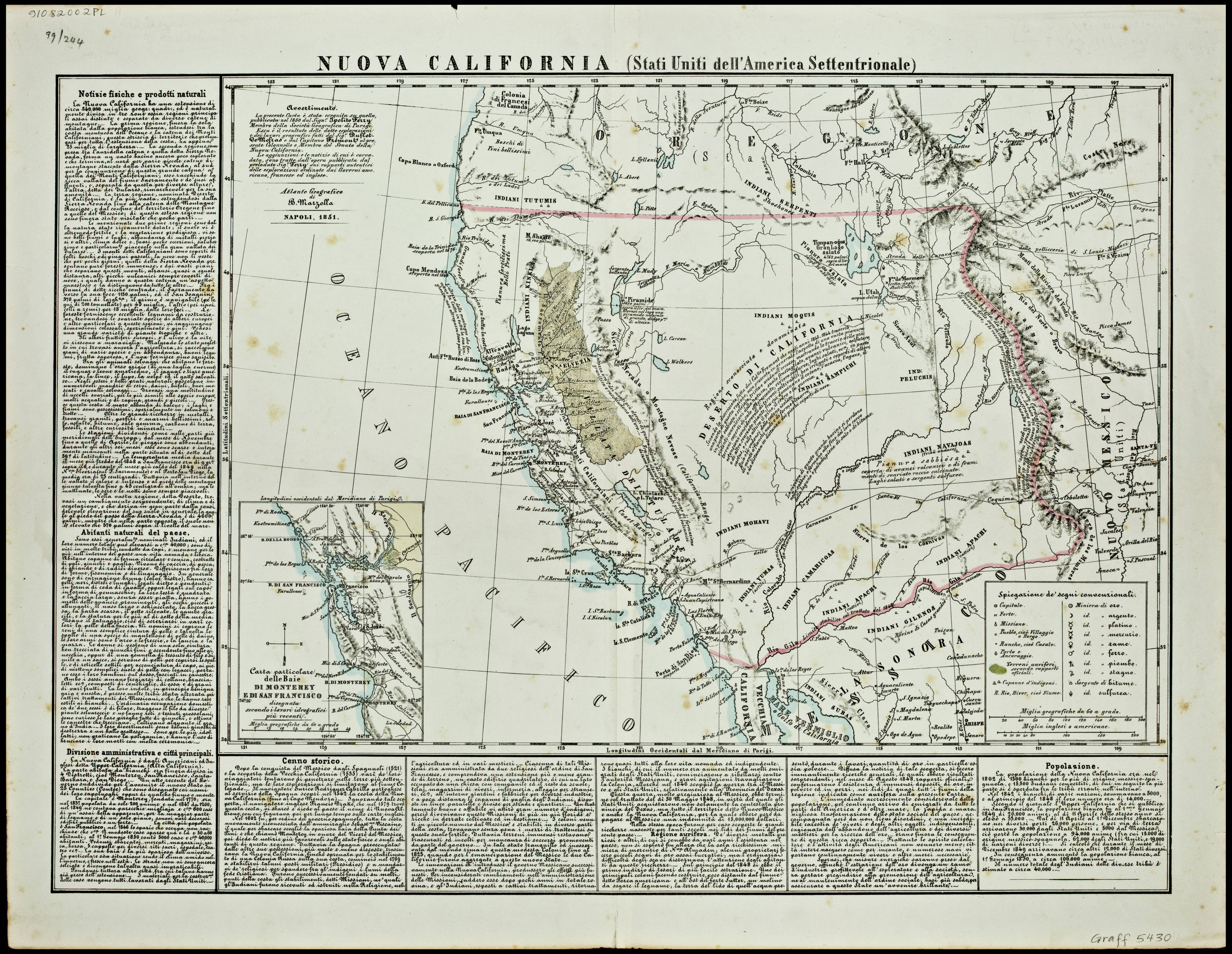
English: Scale (ca. 1,4,400,000); (W 125⁰--W 104⁰ N 44⁰--N 30⁰). Inset, Carta particolare delle Baie di Monterey e di San Francisco, designata secondo i lavori idrografici piu rrecenti. Includes text. Prime meridian, Paris. From Marzolla’s Atlante Geografico. 1851. |
| Date | |
| Source | http://collections.carli.illinois.edu/cdm/singleitem/collection/nby_graff/id/15537 |
| Author | Marzolla, Benedetto, 1801-1858 |
| Permission (Reusing this file) |
The Newberry makes its collections available for any lawful purpose, commercial or non-commercial, without licensing or permission fees to the library, subject to the following terms and conditions: https://www.newberry.org/rights-and-reproductions |
| Format | Maps (Documents) |
| Collection | Everett D. Graff Collection of Western Americana (Newberry Library) |
| Publisher | B. Marzolla |
| Place | United States, West |
| Unique Identifier | GR_5430 |
| Link to Catalog | permalink |
| Call Number | VAULT map Graff 5430 |
Licensing
edit.jpg&action=edit§ion=2)
|
This work is in the public domain in its country of origin and other countries and areas where the copyright term is the author's life plus 100 years or fewer. This work is in the public domain in the United States because it was published (or registered with the U.S. Copyright Office) before January 1, 1929. | |
| This file has been identified as being free of known restrictions under copyright law, including all related and neighboring rights. | |
File history
Click on a date/time to view the file as it appeared at that time.
| Date/Time | Thumbnail | Dimensions | User | Comment | |
|---|---|---|---|---|---|
| current | 22:47, 28 February 2018 | | 3,600 × 2,788 (2.15 MB) | Fæ (talk | contribs) | Newberry Library 15537 |
You cannot overwrite this file.
File usage on Commons
There are no pages that use this file.
.jpg&oldid=782126969)