File:Pannonian sea03-en.png

Size of this preview: 770 × 600 pixels. Other resolutions: 308 × 240 pixels | 617 × 480 pixels | 986 × 768 pixels | 1,280 × 997 pixels | 1,536 × 1,196 pixels.
Original file (1,536 × 1,196 pixels, file size: 109 KB, MIME type: image/png)
Captions
Captions
Add a one-line explanation of what this file represents
Summary
edit
| Description |
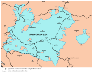
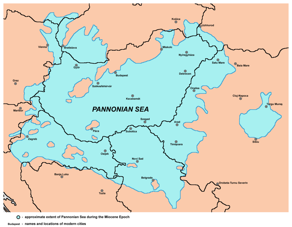
English: Approximate extent of Pannonian Sea during the Miocene Epoch. Српски / srpski: Приближне границе простирања Панонског мора током епохе миоцена. |
| Date | |
| Source | Own work |
| Author | PANONIAN |
Licensing
edit
I, the copyright holder of this work, hereby publish it under the following license:
| This file is made available under the Creative Commons CC0 1.0 Universal Public Domain Dedication. | |
| The person who associated a work with this deed has dedicated the work to the public domain by waiving all of their rights to the work worldwide under copyright law, including all related and neighboring rights, to the extent allowed by law. You can copy, modify, distribute and perform the work, even for commercial purposes, all without asking permission.
|
References
edit
Published references:
- Dragan Rodić, Geografija za I ili III razred srednje škole, Beograd, 1995.
- Dr Dušan J. Popović, Srbi u Vojvodini, knjiga 1, Novi Sad, 1990.
- Dr Aleksa Ivić, Istorija Srba u Vojvodini, Novi Sad, 1929.
- Milan Tutorov, Mala Raška a u Banatu, Zrenjanin, 1991.
- Milan Tutorov, Banatska rapsodija - istorika Zrenjanina i Banata, Novi Sad, 2001.
- Predrag Medović, Praistorija na tlu Vojvodine, Novi Sad, 2001.
Internet references:
- http://www.sulinet.hu/oroksegtar/data/telepulesek_ertekei/Ruzsa/pages/ruzsa_tortenete_es_nepelete/003_termeszeti_foldrajz.htm
- http://www.geology.wisc.edu/~paleo/pannon.gif
- http://paleobiol.geoscienceworld.org/content/38/4/554/F1.large.jpg
- http://openi.nlm.nih.gov/imgs/512/2/3271360/3271360_gr1.png
- http://www.sciencedirect.com/science/article/pii/S0031018298001552
- http://origin-ars.els-cdn.com/content/image/1-s2.0-S0031018298001552-gr7.gif
- http://shebtiw.wordpress.com/2009/11/13/the-sea-in-the-6th-minute/
- http://shebtiw.files.wordpress.com/2009/11/basin.jpg
- http://de.wikipedia.org/w/index.php?title=Datei:Karte_Pannon_See_vor_11,5_Mio._Jahren.JPG&filetimestamp=20051220124116[dead link]
File history
Click on a date/time to view the file as it appeared at that time.
| Date/Time | Thumbnail | Dimensions | User | Comment | |
|---|---|---|---|---|---|
| current | 22:00, 15 November 2013 | | 1,536 × 1,196 (109 KB) | PANONIAN (talk | contribs) | {{Information |Description ={{en|1=Approximate extent of Pannonian Sea during the Miocene Epoch.}} |Source ={{own}} |Author =PANONIAN |Date =2013 |Permission = |other_versions = }} |
You cannot overwrite this file.
File usage on Commons
The following 4 pages use this file:
File usage on other wikis
The following other wikis use this file:
- Usage on fa.wikipedia.org
- Usage on hr.wikipedia.org
- Usage on ro.wikipedia.org
- Usage on sh.wikipedia.org