File:Papal Bulla, probably Innocent IV, nr Downham, Ribble Valley, Lancs. (FindID 87967-51635).jpg

Size of this preview: 649 × 600 pixels. Other resolutions: 260 × 240 pixels | 519 × 480 pixels | 900 × 832 pixels.
Original file (900 × 832 pixels, file size: 147 KB, MIME type: image/jpeg)
Captions
Captions
Add a one-line explanation of what this file represents
Summary
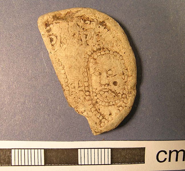
edit| Papal Bulla, probably Innocent IV: nr Downham, Ribble Valley, Lancs. | |||
|---|---|---|---|
| Photographer |
The Portable Antiquities Scheme, Dot Boughton, 2005-02-21 09:48:32 |
||
| Title |
Papal Bulla, probably Innocent IV: nr Downham, Ribble Valley, Lancs. |
||
| Description |
English: One half of a Papal Bulla (lead). The lead seal was possibly broken at its weakest point - where the cord went through the lead - maybe by the recipient himself.
On the obverse is the head of St Peter (on the right) still visible and the letters ()PA()PE which should be read as SPASPE (abbreviation for St PAul and St PEter). On the reverse, the letters INN()CENT()PPI(I?) are still visible. It is thus possible that it was a bulla of Innocent III (1179-80) or Innocent IV (IIII) (1243-54), more likely, however, the latter since Innocent III's reign was considerably shorter. |
||
| Depicted place | (County of findspot) Lancashire | ||
| Date | between 1243 and 1254 | ||
| Accession number |
FindID: 87967 Old ref: LANCUM-A09125 Filename: DownhamPapalBulla1b.JPG |
||
| Credit line |
|
||
| Source |
https://finds.org.uk/database/ajax/download/id/51636 Catalog: https://finds.org.uk/database/images/image/id/51636/recordtype/artefacts archive copy at the Wayback Machine Artefact: https://finds.org.uk/database/artefacts/record/id/87967 |
||
| Permission (Reusing this file) |
Attribution-ShareAlike License | ||
| Other versions |
|
||
.jpg)
.jpg&action=edit§ion=1)
| Object location | | View this and other nearby images on: OpenStreetMap |
|---|
.jpg¶ms=053.885700_N_-002.312470_E_globe:Earth_class:object_type:object__&language=en)
Licensing
edit.jpg&action=edit§ion=2)
This file is licensed under the Creative Commons Attribution-Share Alike 2.0 Generic license.
Attribution: The Portable Antiquities Scheme/ The Trustees of the British Museum
- You are free:
- to share – to copy, distribute and transmit the work
- to remix – to adapt the work
- Under the following conditions:
- attribution – You must give appropriate credit, provide a link to the license, and indicate if changes were made. You may do so in any reasonable manner, but not in any way that suggests the licensor endorses you or your use.
- share alike – If you remix, transform, or build upon the material, you must distribute your contributions under the same or compatible license as the original.
File history
Click on a date/time to view the file as it appeared at that time.
| Date/Time | Thumbnail | Dimensions | User | Comment | |
|---|---|---|---|---|---|
| current | 00:46, 24 February 2017 | | 900 × 832 (147 KB) | Fæ (talk | contribs) | Portable Antiquities Scheme, create missing image based on cross-ref check. FindID 87967, ImageID 51635, batch page 21962 |
You cannot overwrite this file.
File usage on Commons
The following page uses this file:
.jpg)
.jpg&oldid=668605910)