File:Partie orientale du Canada ou de la Nouvelle France - ou sont les provinces, ou pays de Sagvenay, Canada, Acadie etc., les peuples, ou nations des Etechemins, Iroquois, Attiquameches etc., NYPL484235.tiff

Size of this JPG preview of this TIF file: 774 × 599 pixels. Other resolutions: 310 × 240 pixels | 620 × 480 pixels | 992 × 768 pixels | 1,280 × 991 pixels | 2,560 × 1,983 pixels | 6,115 × 4,736 pixels.
Original file (6,115 × 4,736 pixels, file size: 82.86 MB, MIME type: image/tiff)
Captions
Captions
Add a one-line explanation of what this file represents
Summary
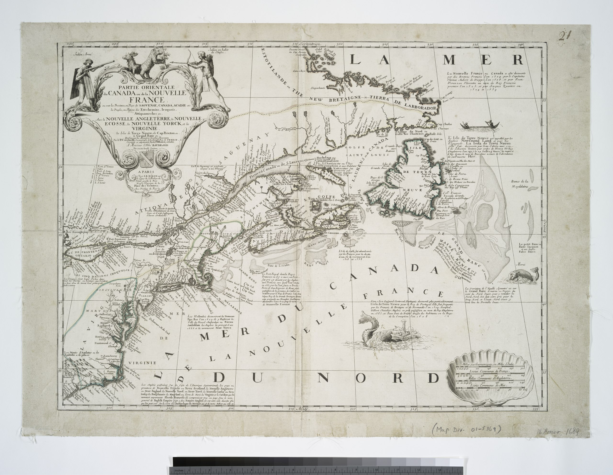
edit| Description | Partie orientale du Canada ou de la Nouvelle France : ou sont les provinces, ou pays de Sagvenay, Canada, Acadie etc., les peuples, ou nations des Etechemins, Iroquois, Attiquameches etc., auec la Nouvelle Angleterre, la Nouvelle Ecosse, la Nouvelle Yorck, et la Virginie, les isles de Terre Neuve, de Cap Breton etc., le Grand Banc etc. / dressee sur les memoires les plus nouveaux par le P. Coronelli, cosmographe de la serenisme. rep. de Venise.; Maps of North America. / Countries / Canada | |||||||||||||||||||||||
| Notes | Shows eastern North America from Labrador to the Carolinas. ''Note 2.'') Relief shown pictorially. ''Note 3.'') "Dediee a Monsieur l'Abb{226}e Baudrand par son tres humble serviteur I.B. Nolin." ''Note 4.'') Outline color. ''Note 5.'') Includes notes and ill. | |||||||||||||||||||||||
| Item physical description | 1 map : hand col. ; 44 x 58 cm. | |||||||||||||||||||||||
| Catalogue call number | Map Div. 01-5369 | |||||||||||||||||||||||
| Standard reference | Kershaw, K.A. Early printed maps of Canada, 1540-1703, 159 | |||||||||||||||||||||||
| Date | ||||||||||||||||||||||||
| Source |
http://digitalgallery.nypl.org/nypldigital/dgkeysearchdetail.cfm?imageID=484235
|
|||||||||||||||||||||||
| Author | Vincenzo, 1650-1718 -- Cartographer Coronelli | |||||||||||||||||||||||
| Permission (Reusing this file) |
From The Lionel Pincus and Princess Firyal Map Division. http://maps.nypl.org
|
|||||||||||||||||||||||
| Location | Stephen A. Schwarzman Building / The Lionel Pincus and Princess Firyal Map Division | |||||||||||||||||||||||
| Digital item published | 2-28-2005; updated 3-25-2011 | |||||||||||||||||||||||
| Digital ID | 484235 | |||||||||||||||||||||||

The making of this file was supported by Wikimedia UK.
To see other files made with the support of Wikimedia UK, please see the category Supported by Wikimedia UK.
|
File history
Click on a date/time to view the file as it appeared at that time.
| Date/Time | Thumbnail | Dimensions | User | Comment | |
|---|---|---|---|---|---|
| current | 23:27, 22 February 2016 |  | 6,115 × 4,736 (82.86 MB) | Finavon (talk | contribs) | rotated |
| 09:22, 3 May 2014 |  | 4,736 × 6,115 (82.86 MB) | Fæ (talk | contribs) | GWToolset:: Creating mediafile for Fæ. Tranche 3 11591-16518 @ 2 May, 06:47 BST |
You cannot overwrite this file.
File usage on Commons
There are no pages that use this file.