File:Philadelphia, the manuft'g & industrial capital in its geographical position to the political & financial capitals of the United States - showing the anthracite coalfields with their railway LOC 79695309.tif

Size of this JPG preview of this TIF file: 475 × 599 pixels. Other resolutions: 190 × 240 pixels | 381 × 480 pixels | 609 × 768 pixels | 812 × 1,024 pixels | 1,624 × 2,048 pixels | 6,120 × 7,716 pixels.
Original file (6,120 × 7,716 pixels, file size: 135.1 MB, MIME type: image/tiff)
Captions
Captions
Add a one-line explanation of what this file represents
Summary edit
| Description |
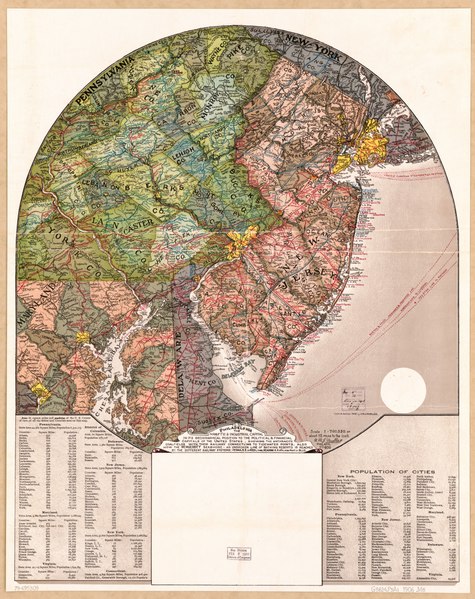
English: Scale 1:760,320 or about 12 miles to the in. "No. 405." Includes tables of county and city population data. Available also through the Library of Congress Web site as a raster image. AACR2 AACR2 |
||
| Title | Philadelphia, the manuft'g & industrial capital in its geographical position to the political & financial capitals of the United States : showing the anthracite coalfields with their railway connections to tidewater points, also how the New Jersey seashore, an unbroken line of bathing resorts, is reached by the different railway systems | ||
| Shelf ID | G3824.P5A1 1906 .M8 | ||
| Date | |||
| Source | https://www.loc.gov/item/79695309/ | ||
| Author | Mueller, A. M. J. | ||
| Permission (Reusing this file) |
|
||
| Other versions |
|
||
| Location | Philadelphia Region · Pennsylvania · Philadelphia Region. · United States | ||
| Part of | Cities And Towns · Transportation And Communication · Catalog · American Memory · Geography And Map Division · Additional Conservation And Environment Cartographic Items | ||
| Subject | Pennsylvania · Philadelphia Region (Pa.) · Railroads · United States · Maps · Philadelphia Region |


Licensing edit
|
This is a faithful photographic reproduction of a two-dimensional, public domain work of art. The work of art itself is in the public domain for the following reason:
The official position taken by the Wikimedia Foundation is that "faithful reproductions of two-dimensional public domain works of art are public domain".
This photographic reproduction is therefore also considered to be in the public domain in the United States. In other jurisdictions, re-use of this content may be restricted; see Reuse of PD-Art photographs for details. | ||||
File history
Click on a date/time to view the file as it appeared at that time.
| Date/Time | Thumbnail | Dimensions | User | Comment | |
|---|---|---|---|---|---|
| current | 22:40, 3 June 2018 |  | 6,120 × 7,716 (135.1 MB) | Fæ (talk | contribs) | LOC Maps https://www.loc.gov/item/79695309/ #19229 |
You cannot overwrite this file.
File usage on Commons
The following page uses this file: