File:Plan de la Baye de la Conception situé par 36. d. 35 ms. latt. sud selon le compas. LOC 90682664.jpg

Size of this preview: 730 × 600 pixels. Other resolutions: 292 × 240 pixels | 584 × 480 pixels | 935 × 768 pixels | 1,246 × 1,024 pixels | 2,492 × 2,048 pixels | 5,730 × 4,709 pixels.
Original file (5,730 × 4,709 pixels, file size: 3.26 MB, MIME type: image/jpeg)
Captions
Captions
Add a one-line explanation of what this file represents
Summary
edit| Description |
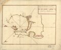
English: Relief shown pictorially. Depths shown by soundings. Oriented with north to the left. Watermarks: Cluster of grapes and indecipherable lettering. Pen-and-ink and watercolor. Mounted on cloth backing. LC Luso-Hispanic World, 199 Available also through the Library of Congress Web site as a raster image. Maggs number annotated in pencil in lower right margin: 29. Vault |
||
| Title | Plan de la Baye de la Conception situé par 36. d. 35 ms. latt. sud selon le compas. | ||
| Shelf ID | G5332.C65 17-- .P48 | ||
| Date | |||
| Source | https://www.loc.gov/item/90682664/ | ||
| Author | Unknown author | ||
| Permission (Reusing this file) |
|
||
| Other versions |
|
||
| Location | Biobío · Concepción Bay (Biobío) · Chile · Pacific Coast · Concepción Bay | ||
| Part of | American Memory · Catalog · Geography And Map Division · Cultural Landscapes | ||
| Subject | Concepción Bay (Biobío, Chile) · Concepción Bay (Biobío) · Maps, Manuscript · Coasts · Maps · Early Works To 1800 · Pacific Coast · Chile · Pacific Coast (Chile) · Manuscript Maps |

Licensing
edit
|
This is a faithful photographic reproduction of a two-dimensional, public domain work of art. The work of art itself is in the public domain for the following reason:
The official position taken by the Wikimedia Foundation is that "faithful reproductions of two-dimensional public domain works of art are public domain".
This photographic reproduction is therefore also considered to be in the public domain in the United States. In other jurisdictions, re-use of this content may be restricted; see Reuse of PD-Art photographs for details. | ||||
File history
Click on a date/time to view the file as it appeared at that time.
| Date/Time | Thumbnail | Dimensions | User | Comment | |
|---|---|---|---|---|---|
| current | 12:37, 6 June 2018 | | 5,730 × 4,709 (3.26 MB) | Fæ (talk | contribs) | LOC Maps https://www.loc.gov/item/90682664/ #21784 |
You cannot overwrite this file.
File usage on Commons
The following page uses this file: