File:Plan der stad Washington - bestemd tot de hoofdstad van America, en ter bestendige verblijfplaats van het Congres, naa het jaar 1800. LOC 88694125.tif

Size of this JPG preview of this TIF file: 752 × 600 pixels. Other resolutions: 301 × 240 pixels | 602 × 480 pixels | 963 × 768 pixels | 1,280 × 1,020 pixels | 2,560 × 2,041 pixels | 3,398 × 2,709 pixels.
Original file (3,398 × 2,709 pixels, file size: 26.34 MB, MIME type: image/tiff)
Captions
Captions
Add a one-line explanation of what this file represents
Summary
edit| Description |
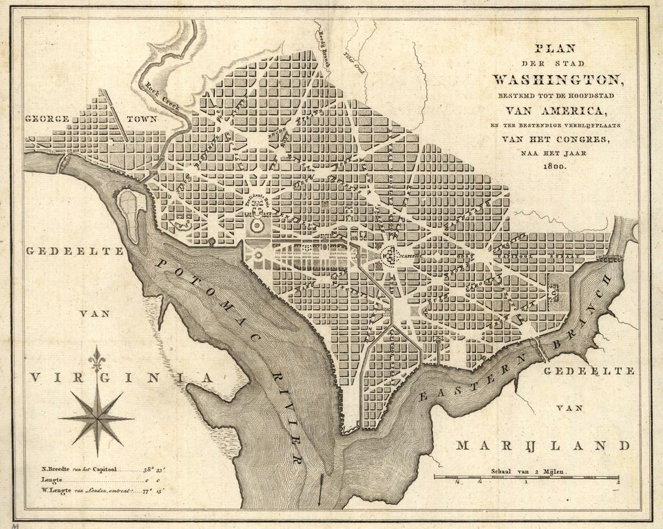
English: Shows proposed government buildings. Relief shown by hachures. Also covers Georgetown. From A. van der Kroe's Vaderlandsche letter-oefeningen waarin boeken en schriften, Amsterdam, 1793, Z1007.V12. Available also through the Library of Congress Web site as a raster image. Includes latitude/longitude statement. LC copy foxed, fold-lined, laminated, and mounted on cloth backing. Phillips. Washington 1287 Vault DCP |
||
| Title | Plan der stad Washington : bestemd tot de hoofdstad van America, en ter bestendige verblijfplaats van het Congres, naa het jaar 1800. | ||
| Shelf ID | G3850 1793 .K7 | ||
| Date | |||
| Source | https://www.loc.gov/item/88694125/ | ||
| Author | Kroe, A. Van Der | ||
| Permission (Reusing this file) |
|
||
| Other versions |
|
||
| Location | Washington D.C. · Georgetown · Washington · United States · District Of Columbia · Georgetown (Washington) | ||
| Part of | American Memory · Cities And Towns · Catalog · Geography And Map Division | ||
| Subject | Washington (D.C.) · Washington · United States · Maps · Early Works To 1800 · District Of Columbia · Georgetown (Washington) · Georgetown (Washington, D.C.) |


Licensing
edit|
This is a faithful photographic reproduction of a two-dimensional, public domain work of art. The work of art itself is in the public domain for the following reason:
The official position taken by the Wikimedia Foundation is that "faithful reproductions of two-dimensional public domain works of art are public domain".
This photographic reproduction is therefore also considered to be in the public domain in the United States. In other jurisdictions, re-use of this content may be restricted; see Reuse of PD-Art photographs for details. | ||||
File history
Click on a date/time to view the file as it appeared at that time.
| Date/Time | Thumbnail | Dimensions | User | Comment | |
|---|---|---|---|---|---|
| current | 06:59, 10 May 2018 |  | 3,398 × 2,709 (26.34 MB) | Fæ (talk | contribs) | LOC Maps https://www.loc.gov/item/88694125/ #339 |
You cannot overwrite this file.
File usage on Commons
The following page uses this file: