File:Plan of the city intended for the permanent seat of the government of t(he) United States - projected agreeable to the direction of the President of the United States, in pursuance of an act of LOC 88694380.tif

Size of this JPG preview of this TIF file: 800 × 591 pixels. Other resolutions: 320 × 237 pixels | 640 × 473 pixels | 1,024 × 757 pixels | 1,280 × 946 pixels | 2,560 × 1,892 pixels | 12,038 × 8,897 pixels.
Original file (12,038 × 8,897 pixels, file size: 306.42 MB, MIME type: image/tiff)
Captions
Captions
Add a one-line explanation of what this file represents
Summary edit
| Warning | The original file is very high-resolution. It might not load properly or could cause your browser to freeze when opened at full size. |
|---|
| Description |
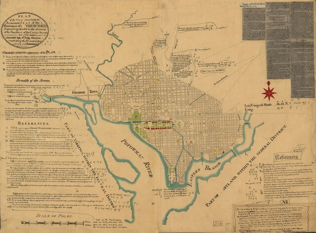
English: Photocopy of a facsim. of the 1791 L'Enfant plan. Original facsim. extensively annotated in ink by Lawrence Martin, chief, Division of Maps, Library of Congress. Includes text, indexed "References," and photocopied newspaper article titled "New city of Washington," from the Gazette of the United States, Philadelphia, Jan. 4, 1792. At lower right: N.I. Available also through the Library of Congress Web site as a raster image. LC copy torn, fold-lined, taped, and accompanied by another photocopy at a smaller scale. DCP |
||
| Title | Plan of the city intended for the permanent seat of the government of t[he] United States : projected agreeable to the direction of the President of the United States, in pursuance of an act of Congress passed the sixteenth day of July, MDCCXC, "establishing the permanent seat on the bank of the Potowmac" : [Washington D.C.] | ||
| Shelf ID | G3850 1791 .L46 1887 | ||
| Date | |||
| Source | https://www.loc.gov/item/88694380/ | ||
| Author | L'Enfant, Pierre Charles; Martin, Lawrence; U.S. Coast And Geodetic Survey | ||
| Permission (Reusing this file) |
|
||
| Other versions |
|
||
| Location | United States · Washington D.C. · District Of Columbia · Washington | ||
| Part of | Military Battles And Campaigns · American Memory · Catalog · Geography And Map Division | ||
| Subject | Washington (D.C.) · Washington · Facsimiles · United States · Maps · Early Works To 1800 · District Of Columbia |

_United_States_-_projected_agreeable_to_the_direction_of_the_President_of_the_United_States,_in_pursuance_of_an_act_of_LOC_88694380.jpg)
Licensing edit
|
This is a faithful photographic reproduction of a two-dimensional, public domain work of art. The work of art itself is in the public domain for the following reason:
The official position taken by the Wikimedia Foundation is that "faithful reproductions of two-dimensional public domain works of art are public domain".
This photographic reproduction is therefore also considered to be in the public domain in the United States. In other jurisdictions, re-use of this content may be restricted; see Reuse of PD-Art photographs for details. | ||||
File history
Click on a date/time to view the file as it appeared at that time.
| Date/Time | Thumbnail | Dimensions | User | Comment | |
|---|---|---|---|---|---|
| current | 00:31, 7 June 2018 |  | 12,038 × 8,897 (306.42 MB) | Fæ (talk | contribs) | LOC Maps https://www.loc.gov/item/88694380/ #7080 |
You cannot overwrite this file.
File usage on Commons
The following page uses this file: