File:Plano de Costa Ricae LOC 90683975.jpg
Size of this preview: 800 × 567 pixels. Other resolutions: 320 × 227 pixels | 640 × 454 pixels | 1,024 × 726 pixels | 1,280 × 907 pixels | 2,560 × 1,814 pixels | 5,640 × 3,997 pixels.
Original file (5,640 × 3,997 pixels, file size: 1.91 MB, MIME type: image/jpeg)
Captions
Captions
Add a one-line explanation of what this file represents
Summary
edit| Description |
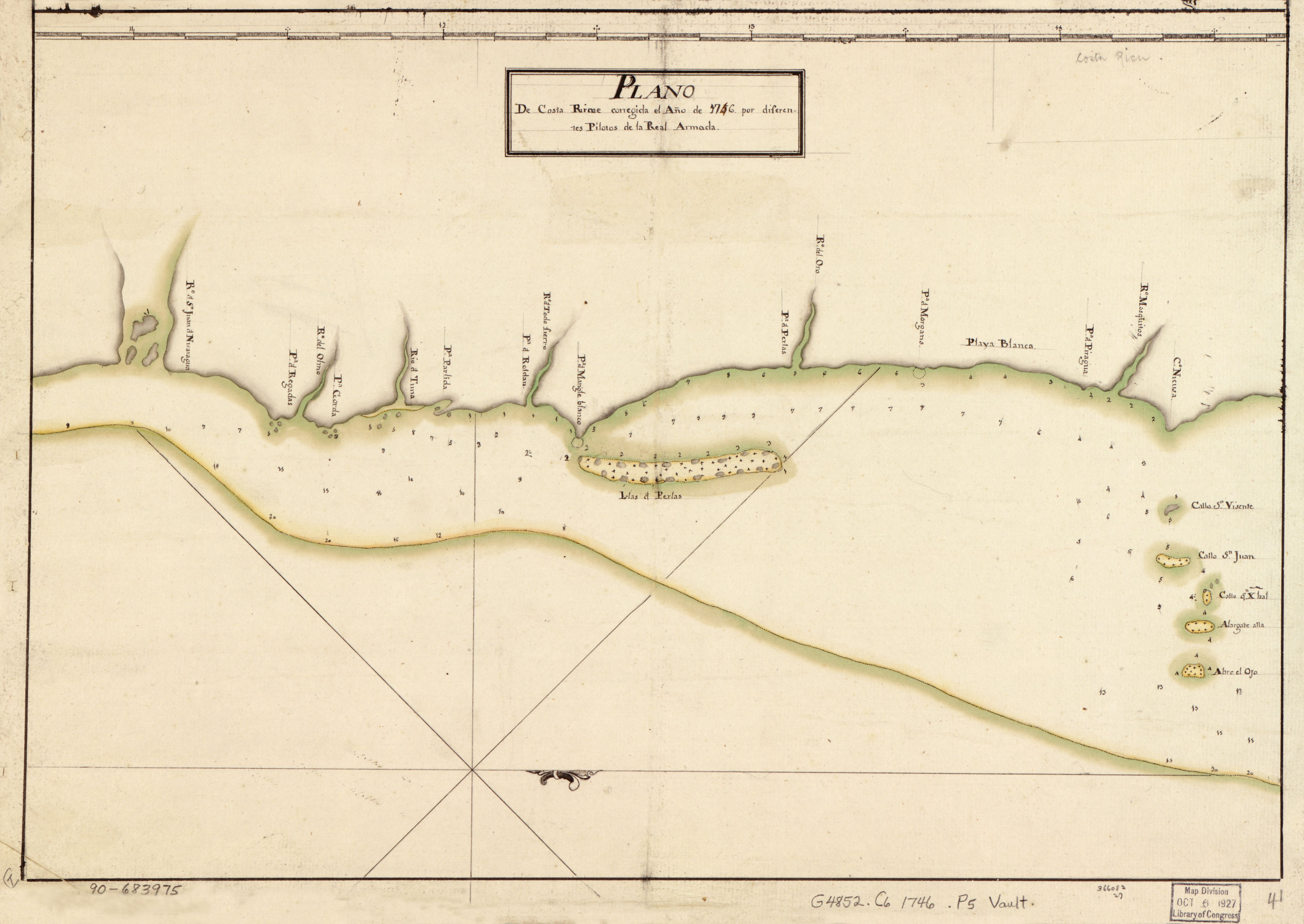
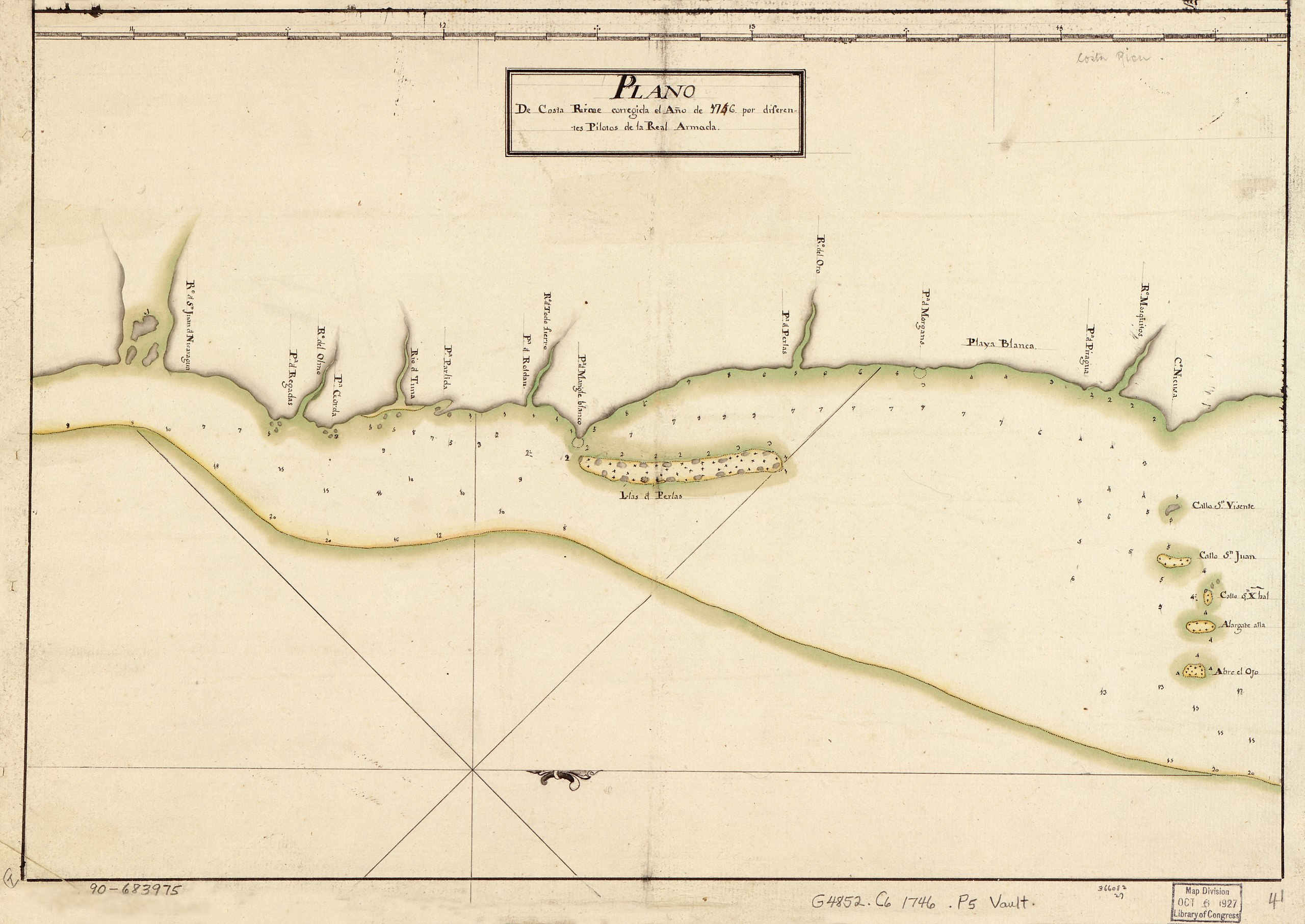
English: Shows lower eastern coast of Nicaragua. Depths shown by soundings. The number 4 in the year 1746 annotated in brown ink over the original number 5 in black ink reflecting change from 1756 to 1746. Oriented with north to the right. Watermark: J. Kool. Pen-and-ink and watercolor. Mounted on cloth backing. LC Luso-Hispanic World, 621 Available also through the Library of Congress Web site as a raster image. Maggs number annotated in pencil in lower right margin: 41. Order number annotated in pencil in lower margin: 366082/27. Vault |
||
| Title | Plano de Costa Ricae | ||
| Shelf ID | G4852.C6 1746 .P5 | ||
| Date | |||
| Source | https://www.loc.gov/item/90683975/ | ||
| Author | Unknown author | ||
| Permission (Reusing this file) |
|
||
| Other versions |
|
||
| Location | Atlantic Coast · Nicaragua | ||
| Part of | American Memory · Catalog · Geography And Map Division · Cultural Landscapes | ||
| Subject | Maps, Manuscript · Coasts · Maps · Early Works To 1800 · Manuscript Maps · Atlantic Coast · Nicaragua · Atlantic Coast (Nicaragua) |


Licensing
edit
|
This is a faithful photographic reproduction of a two-dimensional, public domain work of art. The work of art itself is in the public domain for the following reason:
The official position taken by the Wikimedia Foundation is that "faithful reproductions of two-dimensional public domain works of art are public domain".
This photographic reproduction is therefore also considered to be in the public domain in the United States. In other jurisdictions, re-use of this content may be restricted; see Reuse of PD-Art photographs for details. | ||||
File history
Click on a date/time to view the file as it appeared at that time.
| Date/Time | Thumbnail | Dimensions | User | Comment | |
|---|---|---|---|---|---|
| current | 20:34, 9 May 2018 | | 5,640 × 3,997 (1.91 MB) | Fæ (talk | contribs) | LOC Maps https://www.loc.gov/item/90683975/ #2093 |
You cannot overwrite this file.
File usage on Commons
The following page uses this file: