File:Plano del Golfo del Dariel situado en la costa de el N. de Trra. Firme siendo la Punta de Caribana, el principio la que esta en la altura de 8 gs. 30 ms. N. y en la longd. de 299 gs. 7 ms., meridiano LOC 90680551.jpg

Size of this preview: 800 × 560 pixels. Other resolutions: 320 × 224 pixels | 640 × 448 pixels | 1,024 × 716 pixels | 1,280 × 895 pixels | 2,560 × 1,791 pixels | 8,930 × 6,247 pixels.
Original file (8,930 × 6,247 pixels, file size: 5.02 MB, MIME type: image/jpeg)
Captions
Captions
Add a one-line explanation of what this file represents
Summary edit
| Description |
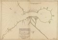
English: Relief shown pictorially. Depths shown by soundings. Prime meridian: Tenerife. Oriented with north toward the upper left. Watermarks: IV; and, Strasburg fleur-de-lis over the characters VDL. Pen-and-ink and watercolor. Mounted on cloth backing. LC Luso-Hispanic World, 262 Available also through the Library of Congress Web site as a raster image. Includes notes. Annotated in black ink in lower sheet: N. 12 [indecipherable]. Maggs number annotated in pencil in lower right corner: 42. Vault |
||
| Title | Plano del Golfo del Dariel situado en la costa de el N. de Trra. Firme siendo la Punta de Caribana, el principio la que esta en la altura de 8 gs. 30 ms. N. y en la longd. de 299 gs. 7 ms., meridiano de Tenerife | ||
| Shelf ID | G5292.U68 1758 .M6 | ||
| Date | |||
| Source | https://www.loc.gov/item/90680551/ | ||
| Author | Modesto Matheos, Antonio | ||
| Permission (Reusing this file) |
|
||
| Other versions |
|
||
| Location | Urabá, Gulf Of. · Colombia · Gulf Of Urab | ||
| Part of | American Memory · Catalog · Geography And Map Division · Cultural Landscapes | ||
| Subject | Maps, Manuscript · Coasts · Urabá, Gulf Of · Early Works To 1800 · Colombia · Urabá, Gulf Of (Colombia) |

Licensing edit
|
This is a faithful photographic reproduction of a two-dimensional, public domain work of art. The work of art itself is in the public domain for the following reason:
The official position taken by the Wikimedia Foundation is that "faithful reproductions of two-dimensional public domain works of art are public domain".
This photographic reproduction is therefore also considered to be in the public domain in the United States. In other jurisdictions, re-use of this content may be restricted; see Reuse of PD-Art photographs for details. | ||||
File history
Click on a date/time to view the file as it appeared at that time.
| Date/Time | Thumbnail | Dimensions | User | Comment | |
|---|---|---|---|---|---|
| current | 04:28, 5 June 2018 | | 8,930 × 6,247 (5.02 MB) | Fæ (talk | contribs) | LOC Maps https://www.loc.gov/item/90680551/ #5238 |
You cannot overwrite this file.
File usage on Commons
The following page uses this file: