File:Plano numero 1. de la barra, y Rio de San Juan desde su entrada hasta dos millas mas arriba del paso de San Nicolas, manifestandose en su curso todos los baxos, sacatales, caños, y ys. las que LOC 2004626373.tif

Size of this JPG preview of this TIF file: 800 × 453 pixels. Other resolutions: 320 × 181 pixels | 640 × 362 pixels | 1,024 × 579 pixels | 1,280 × 724 pixels | 2,560 × 1,449 pixels | 8,548 × 4,837 pixels.
Original file (8,548 × 4,837 pixels, file size: 118.29 MB, MIME type: image/tiff)
Captions
Captions
Add a one-line explanation of what this file represents
Summary edit
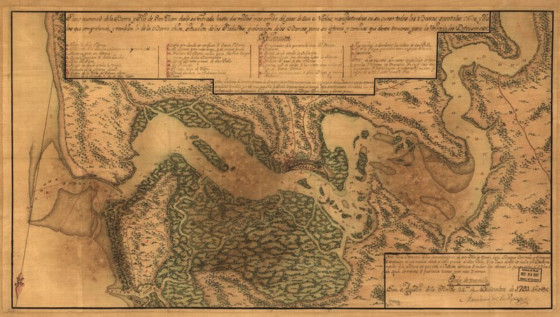
| Description |
English: Covers Saint Johns River and environs from Atlantic coast to current site of Jacksonville, Florida. Relief shown pictorially. Depths shown by soundings. Shows defenses and fortifications. Also shows vegetation pictorially. Bar scale incorrect. Oriented with north toward the lower left. LC Luso-Hispanic world, 884 Pen-and-ink and watercolor. Map backed with cloth. Available also through the Library of Congress Web site as a raster image. Includes notes and index. Imperfect: Darkened and stained. |
||
| Title | Plano numero 1. de la barra, y Rio de San Juan desde su entrada hasta dos millas mas arriba del paso de San Nicolas, manifestandose en su curso todos los baxos, sacatales, caños, y ys. las que comprehende, y tambien la de la barra chica, situacion do los reductos, y colocacion de los barcos para su defenza, y caminos que deven tomarse para la retirada los defensores | ||
| Shelf ID | G3932.S2 1791 .R6 | ||
| Date | |||
| Source | https://www.loc.gov/item/2004626373/ | ||
| Author | Rocque, Mariano De La. | ||
| Permission (Reusing this file) |
|
||
| Other versions |
|
||
| Location | United States · Saint Johns River Region · Florida · Jacksonville Metropolitan Area | ||
| Part of | American Memory · Catalog · Geography And Map Division · Cultural Landscapes | ||
| Subject | Maps, Manuscript · Maps · Fortification · Jacksonville Metropolitan Area (Fla.) · Florida · Jacksonville Metropolitan Area · United States · Saint Johns River Region · Early Works To 1800 · Saint Johns River Region (Fla.) |


Licensing edit
|
This is a faithful photographic reproduction of a two-dimensional, public domain work of art. The work of art itself is in the public domain for the following reason:
The official position taken by the Wikimedia Foundation is that "faithful reproductions of two-dimensional public domain works of art are public domain".
This photographic reproduction is therefore also considered to be in the public domain in the United States. In other jurisdictions, re-use of this content may be restricted; see Reuse of PD-Art photographs for details. | ||||
File history
Click on a date/time to view the file as it appeared at that time.
| Date/Time | Thumbnail | Dimensions | User | Comment | |
|---|---|---|---|---|---|
| current | 04:51, 5 June 2018 |  | 8,548 × 4,837 (118.29 MB) | Fæ (talk | contribs) | LOC Maps https://www.loc.gov/item/2004626373/ #5250 |
You cannot overwrite this file.
File usage on Commons
The following page uses this file: