File:Possible Iron Age ear ring (FindID 224105).jpg
Size of this preview: 730 × 600 pixels. Other resolutions: 292 × 240 pixels | 584 × 480 pixels | 904 × 743 pixels.
Original file (904 × 743 pixels, file size: 333 KB, MIME type: image/jpeg)
Captions
Captions
Add a one-line explanation of what this file represents
Summary
edit.jpg&action=edit§ion=1)
| Possible Iron Age ear ring | |||
|---|---|---|---|
| Photographer |
West Yorkshire Archaeology Service, Amy Downes, 2008-06-26 13:40:58 |
||
| Title |
Possible Iron Age ear ring |
||
| Description |
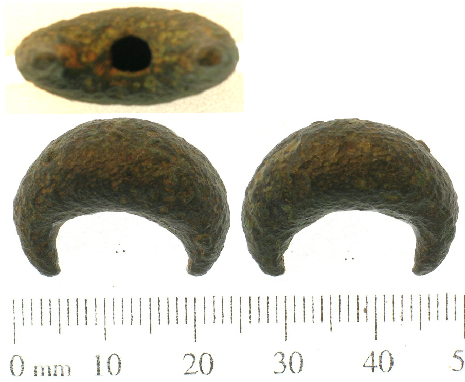
English: A copper-alloy object of uncertain date and function. According to record number BH-439987: “several similar artefacts, identified as ear rings, have been found in the Champagne region of France and are illustrated in the Morel Collection (I.M. Stead and V. Rigby; 1999; fig. 120). They generally date to the late La Tène I period. However, the French examples differ slightly in that they appear to have been made from thin sheet metal and bent and pressed into shape; this piece is heavy, solid and has been cast in one piece.”
This example is also cast, heavy and hollow but does not have the fine decoration of BH-439987. It seems likely that it is of the same date and function though. The object is crescent shaped in plan, hollow and has domed surfaces. The tips of the crescent are worn and may have originally been longer, continuing into a circle. There is a circular hole in the object, underneath where the tips would meet. There is no decoration. The surface is pitted and corroded, but has a deep glossy patina where it survives. The artefact measures 23.4mm long, 18.3mm wide and 11mm thick. The weight is 19.15g. |
||
| Depicted place | (County of findspot) Nottinghamshire | ||
| Date | between 400 BC and 300 BC | ||
| Accession number |
FindID: 224105 Old ref: SWYOR-3A3221 Filename: PAS 807 hilt.jpg |
||
| Credit line |
|
||
| Source |
https://finds.org.uk/database/ajax/download/id/180056 Catalog: https://finds.org.uk/database/images/image/id/180056/recordtype/artefacts archive copy at the Wayback Machine Artefact: https://finds.org.uk/database/artefacts/record/id/224105 |
||
| Permission (Reusing this file) |
Attribution-ShareAlike License | ||
| Object location | | View this and other nearby images on: OpenStreetMap |
|---|
.jpg¶ms=053.382700_N_-001.053640_E_globe:Earth_class:object_type:object__&language=en)
Licensing
edit.jpg&action=edit§ion=2)
This file is licensed under the Creative Commons Attribution-Share Alike 2.0 Generic license.
Attribution: The Portable Antiquities Scheme/ The Trustees of the British Museum
- You are free:
- to share – to copy, distribute and transmit the work
- to remix – to adapt the work
- Under the following conditions:
- attribution – You must give appropriate credit, provide a link to the license, and indicate if changes were made. You may do so in any reasonable manner, but not in any way that suggests the licensor endorses you or your use.
- share alike – If you remix, transform, or build upon the material, you must distribute your contributions under the same or compatible license as the original.
File history
Click on a date/time to view the file as it appeared at that time.
| Date/Time | Thumbnail | Dimensions | User | Comment | |
|---|---|---|---|---|---|
| current | 22:17, 2 February 2017 | | 904 × 743 (333 KB) | Fæ (talk | contribs) | Portable Antiquities Scheme, SWYOR, FindID: 224105, iron age, page 3628, batch sort-updated count 25587 |
You cannot overwrite this file.
File usage on Commons
The following page uses this file:
.jpg)
.jpg&oldid=545090728)