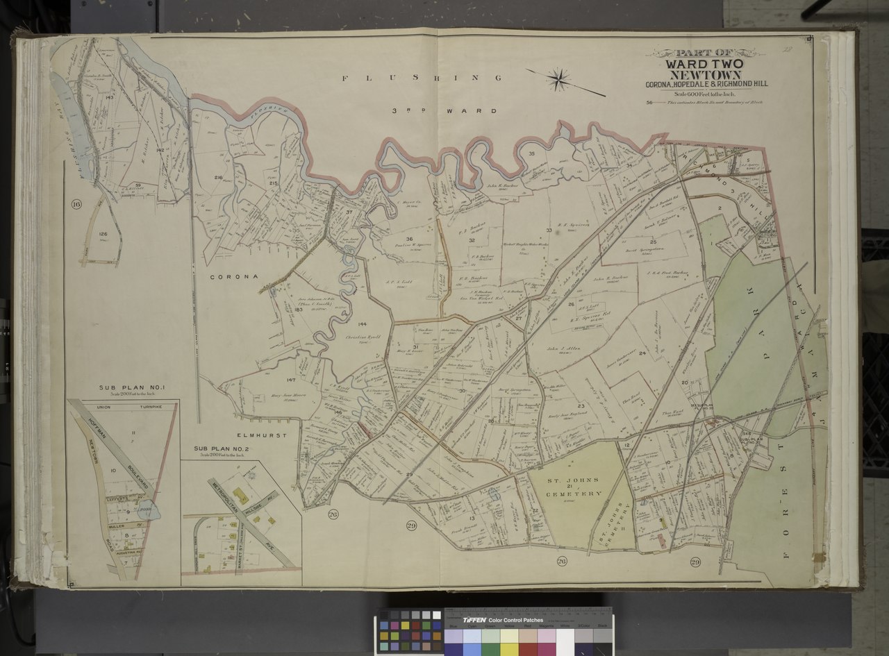
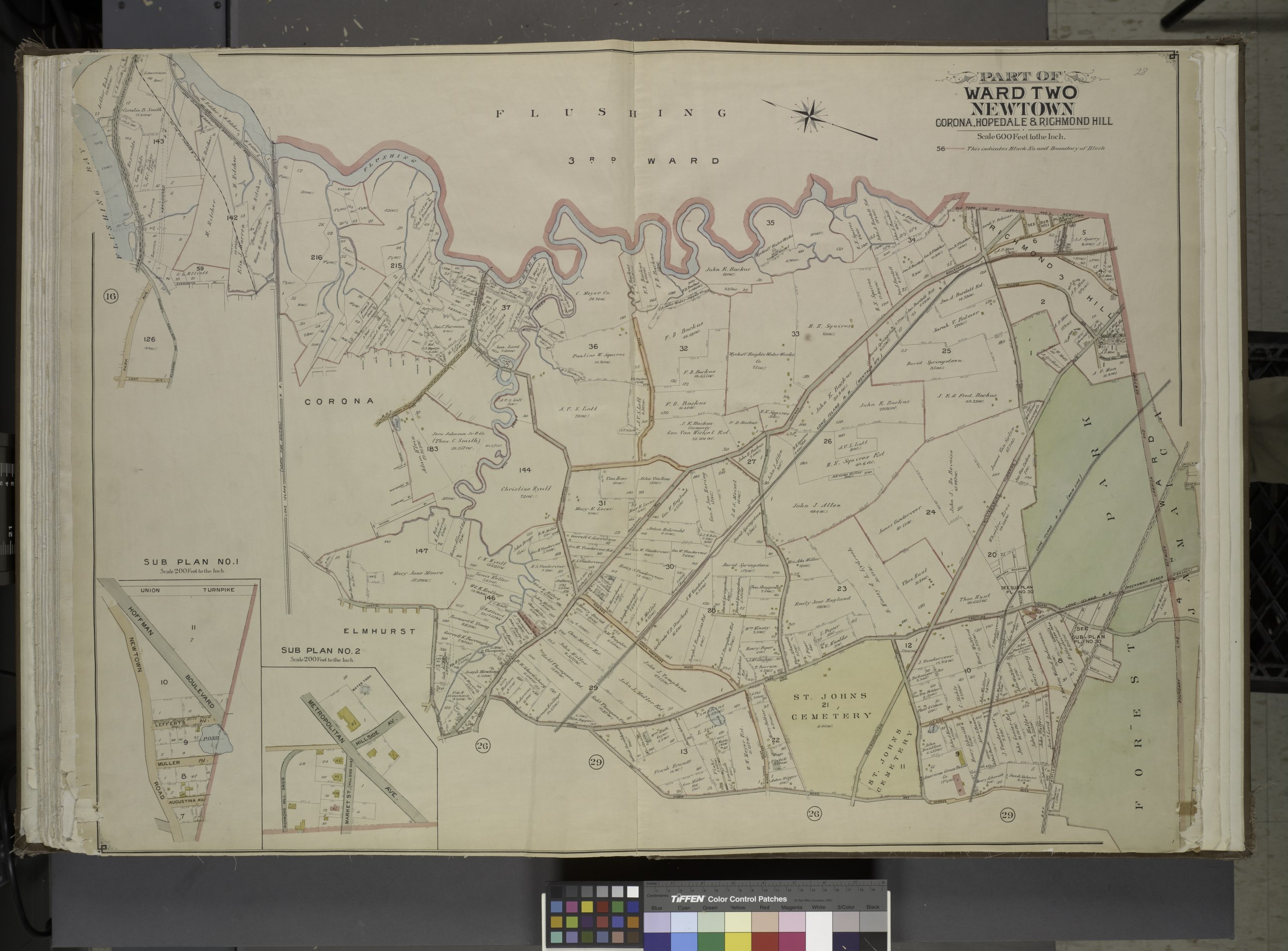
File:Queens, Vol. 2, Double Page Plate No. 28; Part of Ward Two Newtown, Corona, Hopedale and Richmond Hill; (Map bounded by Flushing Creek, Old Town of Jamaica and Newtown, Boundary Line between NYPL1693984.tiff

Size of this JPG preview of this TIF file: 800 × 591 pixels. Other resolutions: 320 × 236 pixels | 640 × 473 pixels | 1,024 × 756 pixels | 1,280 × 945 pixels | 2,560 × 1,890 pixels | 6,898 × 5,094 pixels.
Original file (6,898 × 5,094 pixels, file size: 100.53 MB, MIME type: image/tiff)
Captions
Captions
Add a one-line explanation of what this file represents
Summary
edit| Description | Queens, Vol. 2, Double Page Plate No. 28; Part of Ward Two Newtown, Corona, Hopedale and Richmond Hill; [Map bounded by Flushing Creek, Old Town of Jamaica and Newtown, Boundary Line between Jamaica and Newtown, Dry Harbor Road, Trotting Course Lane, Horse Brook Road; Including Court St., Junction Ave., Grand Ave., Flushing and Newtown Turnpike, Lent Ae., Park Ave., Jackson Causeway]; Sub Plan No.1; [Map bounded by Union Turnpike, Hoffman Boulevard, Newtown Road; Inclluding Lefferts Ave., Muller Ave., Augustina Ave.]; Sub Plan No. 2; [Map bounded by Metropolitan Ave., Hillside Ave.; Including Market St. (Hillside Ave.), Richmond Hill Drive]; Atlases of New York city. / Atlas of the borough of Queens, city of New York : based upon official plans and maps on file in the various city offices; supplemented by careful field measurements and personal observations / by and under the supervision of Hugo Ullitz. / First and second wards: Long Island City and Newtown. | |||||||||||||||||||||||
| Catalogue call number | Map Div.+++ (Queens, New York. 1901-1904) (Hyde, E.B., Map Co., Inc. Atlas of the borough of Queens) | |||||||||||||||||||||||
| Item/Page/Plate | 28 | |||||||||||||||||||||||
| Date | between 1901 and 1904 | |||||||||||||||||||||||
| Source |
http://digitalgallery.nypl.org/nypldigital/dgkeysearchdetail.cfm?imageID=1693984
|
|||||||||||||||||||||||
| Author | ||||||||||||||||||||||||
| Permission (Reusing this file) |
From The Lionel Pincus and Princess Firyal Map Division. http://maps.nypl.org
|
|||||||||||||||||||||||
| Location | Stephen A. Schwarzman Building / The Lionel Pincus and Princess Firyal Map Division | |||||||||||||||||||||||
| Digital item published | 3-4-2009; updated 3-25-2011 | |||||||||||||||||||||||
| Digital ID | 1693984 | |||||||||||||||||||||||

The making of this file was supported by Wikimedia UK.
To see other files made with the support of Wikimedia UK, please see the category Supported by Wikimedia UK.
|
File history
Click on a date/time to view the file as it appeared at that time.
| Date/Time | Thumbnail | Dimensions | User | Comment | |
|---|---|---|---|---|---|
| current | 12:22, 8 May 2014 |  | 6,898 × 5,094 (100.53 MB) | Fæ (talk | contribs) | GWToolset: Creating mediafile for Fæ. Tranche 4 -4989 restart @08:55 BST, 7 May 2014 |
You cannot overwrite this file.
File usage on Commons
There are no pages that use this file.