File:Radar image of Lisbon ESA200829.tiff

Size of this JPG preview of this TIF file: 607 × 600 pixels. Other resolutions: 243 × 240 pixels | 486 × 480 pixels | 777 × 768 pixels | 1,036 × 1,024 pixels | 2,073 × 2,048 pixels | 2,835 × 2,801 pixels.
Original file (2,835 × 2,801 pixels, file size: 22.74 MB, MIME type: image/tiff)
Captions
Captions
Add a one-line explanation of what this file represents
Summary
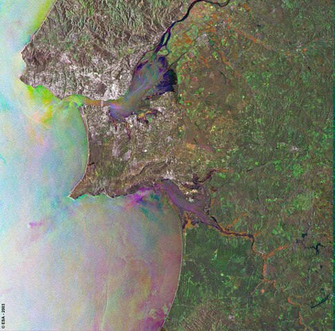
edit| Description |
English: This Envisat's Advanced Synthetic Aperture Radar (ASAR) image shows Lisbon and the surrounding area. The city, capital of Portugal, is visible as a large bright area and is situated on the mouth of the Tagus River, which flows from the top centre of the image. The image is a multitemporal colour composite and is made of three ASAR images acquired on different dates and assigning a colour (RGB) to each date (Red : 26 October 2003, Green : 17 August 2003, Blue : 4 May 2003). |
| Date | |
| Source | http://www.esa.int/spaceinimages/Images/2007/09/Radar_image_of_Lisbon |
| Author | European Space Agency |
| Permission (Reusing this file) |
ESA,CC BY-SA 3.0 IGO |
| Other versions |
|
| Title | Radar image of Lisbon |
| Keywords | Land use |
| Mission | Envisat |
| Activity | Observing the Earth |

Licensing
editThis file is licensed under the Creative Commons Attribution-ShareAlike 3.0 IGO license.
Attribution: ESA
- You are free:
- to share – to copy, distribute and transmit the work
- to remix – to adapt the work
- Under the following conditions:
- attribution – You must give appropriate credit, provide a link to the license, and indicate if changes were made. You may do so in any reasonable manner, but not in any way that suggests the licensor endorses you or your use.
- share alike – If you remix, transform, or build upon the material, you must distribute your contributions under the same or compatible license as the original.
File history
Click on a date/time to view the file as it appeared at that time.
| Date/Time | Thumbnail | Dimensions | User | Comment | |
|---|---|---|---|---|---|
| current | 18:24, 24 May 2017 |  | 2,835 × 2,801 (22.74 MB) | Fæ (talk | contribs) | European Space Agency, Id 200829, http://www.esa.int/spaceinimages/Images/2007/09/Radar_image_of_Lisbon, User:Fæ/Project_list/ESA |
You cannot overwrite this file.
File usage on Commons
The following page uses this file: