File:Railroad map of the eastern, western and northern states, and Canada, showing conspicuously the lines of communication between the ports of the Atlantic and the great west and north west. LOC 98688326.jpg

Size of this preview: 800 × 441 pixels. Other resolutions: 320 × 177 pixels | 640 × 353 pixels | 1,024 × 565 pixels | 1,280 × 706 pixels | 2,560 × 1,413 pixels | 14,064 × 7,760 pixels.
Original file (14,064 × 7,760 pixels, file size: 18.33 MB, MIME type: image/jpeg)
Captions
Captions
Add a one-line explanation of what this file represents
Summary edit
| Warning | The original file is very high-resolution. It might not load properly or could cause your browser to freeze when opened at full size. |
|---|
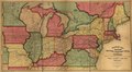
| Description |
English: General map covering the northeastern and north-central United States and part of eastern Canada. Shows drainage, cities, roads, canals, and "railroads completed" and "in progress." |
||
| Title | Railroad map of the eastern, western and northern states, and Canada, showing conspicuously the lines of communication between the ports of the Atlantic and the great west and north west. | ||
| Shelf ID | G3701.P3 1859 .M5 | ||
| Date | |||
| Source | https://www.loc.gov/item/98688326/ | ||
| Author | Mitchell'S Map Publication Office; Mitchell, S. Augustus (Samuel Augustus) | ||
| Permission (Reusing this file) |
|
||
| Other versions |
|
||
| Location | United States | ||
| Part of | American Memory · Catalog · Railroad Maps, 1828-1900 · Geography And Map Division · Transportation And Communication | ||
| Subject | United States · Maps · Railroads |

Licensing edit
|
This is a faithful photographic reproduction of a two-dimensional, public domain work of art. The work of art itself is in the public domain for the following reason:
The official position taken by the Wikimedia Foundation is that "faithful reproductions of two-dimensional public domain works of art are public domain".
This photographic reproduction is therefore also considered to be in the public domain in the United States. In other jurisdictions, re-use of this content may be restricted; see Reuse of PD-Art photographs for details. | ||||
File history
Click on a date/time to view the file as it appeared at that time.
| Date/Time | Thumbnail | Dimensions | User | Comment | |
|---|---|---|---|---|---|
| current | 00:10, 31 May 2018 | | 14,064 × 7,760 (18.33 MB) | Fæ (talk | contribs) | LOC Maps https://www.loc.gov/item/98688326/ #15707 |
You cannot overwrite this file.
File usage on Commons
The following page uses this file: