File:Rand, McNally & Co.'s map of the United States showing, in six degrees the density of population, 1890. LOC 99446196.jpg

Size of this preview: 800 × 507 pixels. Other resolutions: 320 × 203 pixels | 640 × 406 pixels | 1,024 × 649 pixels | 1,280 × 811 pixels | 2,560 × 1,622 pixels | 6,144 × 3,893 pixels.
Original file (6,144 × 3,893 pixels, file size: 5.53 MB, MIME type: image/jpeg)
Captions
Captions
Add a one-line explanation of what this file represents
Summary edit
| Description |
English: Available also through the Library of Congress web site as a raster image. |
||
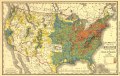
| Title | Rand, McNally & Co.'s map of the United States showing, in six degrees the density of population, 1890. | ||
| Shelf ID | G3701.E2 1892 .R3 TIL | ||
| Date | |||
| Source | https://www.loc.gov/item/99446196/ | ||
| Author | Rand Mcnally And Company | ||
| Permission (Reusing this file) |
|
||
| Other versions |
|
||
| Location | United States | ||
| Part of | American Memory · Catalog · Geography And Map Division · Cultural Landscapes | ||
| Subject | United States · Maps · Population Density |

Licensing edit
|
This is a faithful photographic reproduction of a two-dimensional, public domain work of art. The work of art itself is in the public domain for the following reason:
The official position taken by the Wikimedia Foundation is that "faithful reproductions of two-dimensional public domain works of art are public domain".
This photographic reproduction is therefore also considered to be in the public domain in the United States. In other jurisdictions, re-use of this content may be restricted; see Reuse of PD-Art photographs for details. | ||||
File history
Click on a date/time to view the file as it appeared at that time.
| Date/Time | Thumbnail | Dimensions | User | Comment | |
|---|---|---|---|---|---|
| current | 08:54, 31 May 2018 | | 6,144 × 3,893 (5.53 MB) | Fæ (talk | contribs) | LOC Maps https://www.loc.gov/item/99446196/ #16087 |
You cannot overwrite this file.
File usage on Commons
The following page uses this file: