File:Rann of Kutch, India ESA377539.tiff

Original file (4,542 × 3,755 pixels, file size: 48.82 MB, MIME type: image/tiff)
Captions
Captions
Summary edit
| Description |
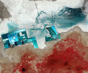
English: The Sentinel-2A satellite takes us over western India to a seasonal salt marsh known as the Rann of Kutch.
One of the largest salt deserts in the world, the area fills with water during the summer monsoon season. During the drier winter, the vast white desert is a popular tourist destination, particularly for the Rann Utsav festival centred around a luxury ‘tent city’, visible in the central-right part of the image as a series of semi-circles. Large salt evaporation ponds dominate this satellite image. One of the major projects in this area is the production of potassium sulphate, which is commonly used in fertiliser. To give an indication of the size of these ponds, the width of the cluster on the left is nearly 13 km across. The lines in the upper-central part of the image are ditches used to control the flow of the water for the ponds. In this false-colour image, shades of blue in the pools and surrounding land come from varying mineral content, as well as the different depths of the pools. Meanwhile, vegetation appears red as seen in the lower part of the image. This area is the Banni grasslands, known for its rich biodiversity. The grasslands area was formed from sediments deposited by rivers including the Indus River, before an earthquake in 1819 changed its course. Today, Banni’s vegetation is sparse and highly dependent on rainfall, but reoccurring droughts are increasing pressure on the arid region. Other factors, including overgrazing and the invasion of a non-native thorny shrub, are also stressing the environment. This image, also featured on theEarth from Space video programme, was captured by the Copernicus Sentinel-2A satellite on 16 December 2015. |
| Date | |
| Source | http://www.esa.int/spaceinimages/Images/2017/05/Rann_of_Kutch_India |
| Author | European Space Agency |
| Permission (Reusing this file) |
contains modified Copernicus Sentinel data (2015), processed by ESA,CC BY-SA 3.0 IGO |
| Other versions |
|
| Title | Rann of Kutch, India |
| Set | Earth observation image of the week |
| System | Copernicus |
| Mission | Sentinel-2 |
| Location | India |
| Activity | Observing the Earth |
| Keywords | Deserts; Grasslands; Satellite image |

Licensing edit
- You are free:
- to share – to copy, distribute and transmit the work
- to remix – to adapt the work
- Under the following conditions:
- attribution – You must give appropriate credit, provide a link to the license, and indicate if changes were made. You may do so in any reasonable manner, but not in any way that suggests the licensor endorses you or your use.
- share alike – If you remix, transform, or build upon the material, you must distribute your contributions under the same or compatible license as the original.

|
This image contains data from a satellite in the Copernicus Programme, such as Sentinel-1, Sentinel-2 or Sentinel-3. Attribution is required when using this image.
Attribution: Contains modified Copernicus Sentinel data {{{year}}}
The use of Copernicus Sentinel Data is regulated under EU law (Commission Delegated Regulation (EU) No 1159/2013 and Regulation (EU) No 377/2014). Relevant excerpts:
Free access shall be given to GMES dedicated data [...] made available through GMES dissemination platforms [...].
Access to GMES dedicated data [...] shall be given for the purpose of the following use in so far as it is lawful:
GMES dedicated data [...] may be used worldwide without limitations in time.
GMES dedicated data and GMES service information are provided to users without any express or implied warranty, including as regards quality and suitability for any purpose. |
File history
Click on a date/time to view the file as it appeared at that time.
| Date/Time | Thumbnail | Dimensions | User | Comment | |
|---|---|---|---|---|---|
| current | 14:00, 23 May 2017 |  | 4,542 × 3,755 (48.82 MB) | Fæ (talk | contribs) | European Space Agency, Id 377539, http://www.esa.int/spaceinimages/Images/2017/05/Rann_of_Kutch_India, User:Fæ/Project_list/ESA |
You cannot overwrite this file.
File usage on Commons
The following page uses this file: