File:Saint Vincent, particulars of two valuable Sugar Estates - called "Richmond Vale" & "Golden Grove," lying together, and situate in the Parish of Saint David, in the Island of St. Vincent, LOC 2016586615-3.jpg
Size of this preview: 513 × 600 pixels. Other resolutions: 205 × 240 pixels | 410 × 480 pixels | 657 × 768 pixels | 876 × 1,024 pixels | 1,751 × 2,048 pixels | 5,346 × 6,251 pixels.
Original file (5,346 × 6,251 pixels, file size: 2.05 MB, MIME type: image/jpeg)
Captions
Captions
Add a one-line explanation of what this file represents
Summary
edit| Description |
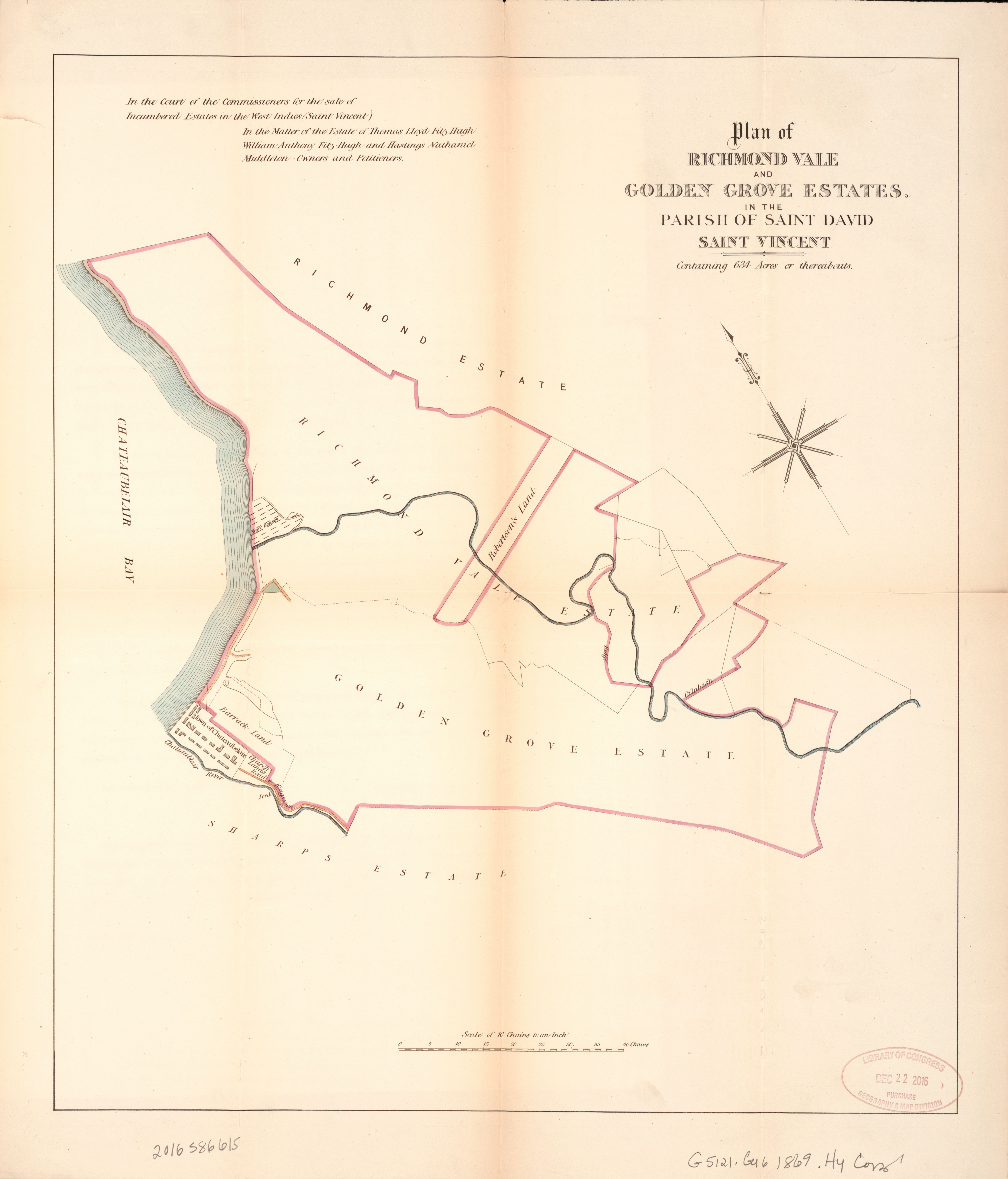
English: Title from accompanying text. "In the matter of the Estate of Thomas Llyod Fitz-Hugh, William Anthony Fitz-Hugh and Hastings Nathaniel Middleton, owners and petitioners." "Sale on Wednesday, the 28th day of July, 1869." Accompanied by text: In the Court of the Commissioners for Sale of Incumbered Estates in the West Indies, Saint Vincent. ([4] unnumbered pages : cadastral data, annotations ; 46 cm, folded to 29 x 12 cm). "At the Auction Mart, Tokenhouse Yard, Lothbury, in the city of London, on Wednesday, the 28th day of July, 1869, at one o'clock precisely. The purchaser will have an indefeasible Parliamentary Title under the Seal of the Court." Oriented with north to the right. "[15395-28-7-69]." Copy imperfect: Use-worn, torn along fold lines. Available also through the Library of Congress Web site as a raster image. |
||
| Title | Saint Vincent, particulars of two valuable Sugar Estates : called "Richmond Vale" & "Golden Grove," lying together, and situate in the Parish of Saint David, in the Island of St. Vincent, containing 634 acres, or thereabouts : which will be sold by auction, in one lot, by Messrs. Hards, Vaughan & Leifchild, before James Fleming, Esq. Q.C., and Reginald John Cust, Esq., Commissioners for Sale of Incumbered Estates in the West Indies, at the Sale Room of the Commissioners. | ||
| Shelf ID | G5121.G46 1869 .H4 | ||
| Parent | https://www.loc.gov/resource/g5121gm.gct00473/ | ||
| Sheet title | Plan of Richmond Vale | ||
| Date | |||
| Source | https://www.loc.gov/item/2016586615/ | ||
| Author | Hards, Vaughan & Leifchild (Firm) | ||
| Permission (Reusing this file) |
|
||
| Other versions |
|
||
| Location | The Grenadines · Saint Vincent. · Saint Vincent | ||
| Part of | American Memory · Catalog · County Landownership Maps · Geography And Map Division · Cultural Landscapes | ||
| Subject | Cadastral Maps · Sir · Sugarcane · Saint Vincent · Maps · Cust, Reginald John · Saint Vincent And The Grenadines · Owner · Estates · Real Property · Landowners |


Licensing
edit
|
This is a faithful photographic reproduction of a two-dimensional, public domain work of art. The work of art itself is in the public domain for the following reason:
The official position taken by the Wikimedia Foundation is that "faithful reproductions of two-dimensional public domain works of art are public domain".
This photographic reproduction is therefore also considered to be in the public domain in the United States. In other jurisdictions, re-use of this content may be restricted; see Reuse of PD-Art photographs for details. | ||||
File history
Click on a date/time to view the file as it appeared at that time.
| Date/Time | Thumbnail | Dimensions | User | Comment | |
|---|---|---|---|---|---|
| current | 23:14, 27 August 2018 | | 5,346 × 6,251 (2.05 MB) | Fæ (talk | contribs) | LOC Maps multisheet https://www.loc.gov/item/2016586615/ sheet 3 of 5 #19068 |
You cannot overwrite this file.
File usage on Commons
The following page uses this file: