File:Saranac Lake, New York LOC 78695391.jpg

Size of this preview: 800 × 504 pixels. Other resolutions: 320 × 202 pixels | 640 × 403 pixels | 1,024 × 645 pixels | 1,280 × 807 pixels | 2,560 × 1,613 pixels | 11,369 × 7,165 pixels.
Original file (11,369 × 7,165 pixels, file size: 17.79 MB, MIME type: image/jpeg)
Captions
Captions
Add a one-line explanation of what this file represents
Summary edit
| Warning | The original file is very high-resolution. It might not load properly or could cause your browser to freeze when opened at full size. |
|---|
| Description |
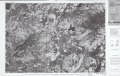
English: Scale 1:25,000; 1 cm. to 250 m. Folded title: 1:25,000-scale orthophotoquad of Saranac Lake, New York : an aerial photographic image showing highways, roads, and other manmade structures, water features, woodland and agricultural lands, selected geographic names. "Orthophotograph prepared from 1:80,000-scale aerial photographs taken May 13, 1976." "Projection and 1000-meter grid, zone 18: universal transverse Mercator." Covers Saranac Lake region. "4474-141-Q25." Includes text, location map, and index map. Available also through the Library of Congress Web site as a raster image. AACR2: 110; 651 |
||
| Title | Saranac Lake, New York | ||
| Shelf ID | G3804.S28A4 1976 .U5 | ||
| Date | |||
| Source | https://www.loc.gov/item/78695391/ | ||
| Author | Geological Survey (U.S.) | ||
| Permission (Reusing this file) |
|
||
| Other versions |
|
||
| Location | United States · New York · New York (State) · Saranac Lake Region | ||
| Part of | American Memory · General Maps · Catalog · Geography And Map Division | ||
| Subject | United States · Remote-Sensing Maps · New York (State) · Saranac Lake Region (N.Y.) · Saranac Lake Region |

Licensing edit
| This work is from the Library of Congress. According to the library, there are no known copyright restrictions on the use of this work. |  |
File history
Click on a date/time to view the file as it appeared at that time.
| Date/Time | Thumbnail | Dimensions | User | Comment | |
|---|---|---|---|---|---|
| current | 06:32, 3 June 2018 | | 11,369 × 7,165 (17.79 MB) | Fæ (talk | contribs) | LOC Maps https://www.loc.gov/item/78695391/ #18700 |
You cannot overwrite this file.
File usage on Commons
The following page uses this file: