File:Sectional map of southern Minnesota LOC 2012593518.jpg

Size of this preview: 800 × 506 pixels. Other resolutions: 320 × 203 pixels | 640 × 405 pixels | 1,024 × 648 pixels | 1,280 × 810 pixels | 2,560 × 1,620 pixels | 9,490 × 6,007 pixels.
Original file (9,490 × 6,007 pixels, file size: 8.57 MB, MIME type: image/jpeg)
Captions
Captions
Add a one-line explanation of what this file represents
Summary edit
| Description |
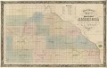
English: "Entered accordinly to Act of Congress in the year 1855 by S. Holsteen in the Clerks Office of the District Court of Minnesota." LC Land ownership maps, 641 Available also through the Library of Congress Web site as a raster image. Includes population statistical table. |
||
| Title | Sectional map of southern Minnesota | ||
| Shelf ID | G4140 1855 .H6 | ||
| Date | |||
| Source | https://www.loc.gov/item/2012593518/ | ||
| Author | Holsteen, S.; Mendel, Edward | ||
| Permission (Reusing this file) |
|
||
| Other versions |
|
||
| Location | United States · Minnesota | ||
| Part of | American Memory · Catalog · County Landownership Maps · Geography And Map Division · Cultural Landscapes | ||
| Subject | United States · Maps · Cadastral Maps · Landowners · Minnesota |

Licensing edit
|
This is a faithful photographic reproduction of a two-dimensional, public domain work of art. The work of art itself is in the public domain for the following reason:
The official position taken by the Wikimedia Foundation is that "faithful reproductions of two-dimensional public domain works of art are public domain".
This photographic reproduction is therefore also considered to be in the public domain in the United States. In other jurisdictions, re-use of this content may be restricted; see Reuse of PD-Art photographs for details. | ||||
File history
Click on a date/time to view the file as it appeared at that time.
| Date/Time | Thumbnail | Dimensions | User | Comment | |
|---|---|---|---|---|---|
| current | 14:52, 17 May 2018 | | 9,490 × 6,007 (8.57 MB) | Fæ (talk | contribs) | LOC Maps https://www.loc.gov/item/2012593518/ #10249 |
You cannot overwrite this file.
File usage on Commons
The following page uses this file: